
West Shepard Avenue Junk Piles
 |
This annotated aerial photo from the 2019 Hamden GIS maps shows the former privately owned property at 574 West Shepard Avenue rear as highlighted in gray. The green arrow points to an area of state property that the former property owner cleared. The logs visible in 2006 are long gone. The red arrow points to the junk pile on state land with the white PVC pipes clearly visible. The road is incorrectly labeled as Baldwin Drive. The GIS maps list three properties as all being 574 West Shepard Avenue Rear: two on the west side of West Shepard Avenue, and one on the east side . |
Various parts of West Rock Ridge State Park have been negatively affected by dumping.
One page on this site focuses on the junkyard formerly off the Red Trail near Mountain Road: https://westrocktrails.blogspot.com/p/west-rock-junkyard-cleanups.html
Another page discusses Baldwin Drive: https://westrocktrails.blogspot.com/p/west-rock-junk-cleanups-baldwin-drive.html
This page discusses two junk areas off West Shepard Avenue.
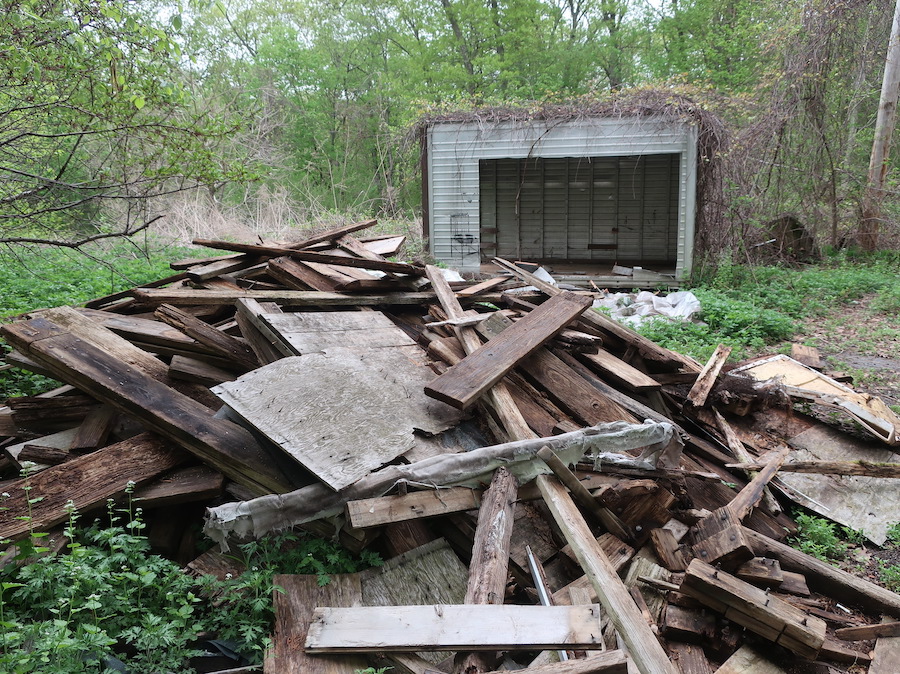
Off West Shepard Avenue, the smaller junk area about 0.1 acres in size is located on the west side of the road, 0.05 miles north of the gate by Rayzoe Terrace. To keep anything from growing, someone placed two-inch thick foam insulation pads on the ground in the entire area. The PVC pipes placed there can easily be seen in the aerial photos from the Hamden GIS maps prior to the cleanup I organized.
The larger of these two areas is about 0.3 acres in size, on the east side of West Shepard Avenue, about 0.15 miles north of the gate at the junction with Rayzoe Terrace, opposite the driveway to the boarded-up house. This area is now heavily infested with invasive plants, including prickly multi-flora rose, thorny wineberry, aromatic garlic mustard, and mostly the mugwort reed.
 |
When the homeowner on West Shepard Avenue was still alive, he would pile stumps and brush at the junction with the gravel Sanford Road, as seen on Oct. 31, 2009. These stumps and logs are long gone by 2025. To the left is the pile of rocks at the end of Baldwin Drive (not seen in this picture). I dug out a carpet about 16 feet long by 4 feet wide in March 2025. |
The West Shepard Avenue junk piles were created by the former homeowner at 574 West Shepard Avenue Rear, the house on the west side of the road between the gate by Rayzoe Terrace and Baldwin Drive. The homeowner was described by those who knew him as a “character” who did what he wanted and was using state land for his own purposes, cutting down trees, clearing areas for his personal use, and allowing contractors to dispose of the larger items.
As I have been involved with this cleanup, I talk with people who walk the road, and ask them if they knew the homeowner. Those who knew him said that he allowed the dumping to take place. For anyone, I want them to know that the wood and trash they see along the road are part of a cleanup in the woods, and that these are not freshly dumped items.
One hiking friend said he spoke to the man during the 1990s who told him that he would charge people to drop off the wood, but his cost was less than they would pay at the transfer station. He would process them into firewood to sell. The friend said the homeowner told him he had to sell about eight cords of firewood to sell to make it worth his while. He would also keep wood for use at his house.
Another hiking friend said the homeowner showed him the deer heads during the early 2000s that he had mounted in his barn, which he had shot in another state. However, there are stories from park users who knew him that he was hunting at West Rock where hunting is illegal. As further proof of this, there are two hunting tree stands in the woods between the house and Baldwin Drive.
Those who have taken a closer look at the house, including one of the property surveyors, said it has neither a sewer connection, nor a septic tank, just a pipe int the yard.
 |
| A metal tree stand used for hunting rests against a tree west of the house as seen in December 2022, and is a few hundred feet west of a wooden tree that that was partially collapsed. |
The homeowner died in 2011 and the family let the property just sit there before Citibank and subsequently the Federal National Mortgage Association (Fannie Mae) took possession in 2017. The state of Connecticut wanted to add the 3.23-acre property to the park, but there was at a stalemate for years over the required paperwork to complete the sale. Apparently, Fannie Mae had certain forms it wanted completed and the state, being the state, had its own way of doing things, and the two sides could not agree, so the property remained unsold.
The stalemate was broken in 2023 when an anonymous donor fronted the $80,000 needed for the West Rock Ridge Park Association to buy the property, which it did on January 12, 2023. The association, in turn, sold the property to the state on March 30, 2023, filling a gap in state property ownership in that area. While the association owned the property, volunteers removed much of the remaining items left in the yard in the immediate area of the house and barn.
The state plans to tear down the house and barn as there no use for it. I am not aware of any specific timeline as to when this will happen. Typically for the state of Connecticut, such actions take a long time.
 |
Fifty-gallon drums and a couch are among the items on the property between the house and barn that were removed by volunteers from the West Rock Ridge Park Association in winter 2023, seen here in October 2019. While an eyesore, at least these items were on the homeowner's property. |
Once the state took ownership, it placed a lock on the gate to keep out people from driving up the road. One person took exception to the lock and apparently cut off the lock and painted words on the sign complaining about the illegal lock. Apparently someone from the state talked to him about it because the lock was replaced and left undamaged, and the state also painted over what he wrote. While the gate was open, someone twice dragged a large rock off the barrier to Baldwin Drive that Hamden had placed there on the state's behalf to keep ATVs and other vehicles off Baldwin Drive. That rock has not been put back, but rests off to the side.
West Shepard Avenue West Side Junkpile
Having done trail work at West Rock since 2007 and having hiked and bicycled at the park since the 1990s, I had seen the junk pile on the west side of West Shepard Avenue. I never met the homeowner who lived there, but I certainly have seen the things left behind, presumably by him.
The 25.79-acre property on the west side of the road was owned by a family member until the state purchased it on June 20, 2008. At that point, any items left in the area should have been removed, but they were not.
I worked on the project on the west side of the road starting in January 2018 and worked on it periodically through the year, mostly by myself and occasionally with help from others. I then did nothing on this project again until one visit in September 2021 and another in May 2022. Finally, I returned to project on a more regular basis with five visits from October and November 2022.
With those visits, I pulled up the foam insulation placed on the ground to keep things from growing, as I collected the trash and stacked the bricks. I carried out bags and buckets filed with trash for proper disposal off-site. In 2018, another volunteer removed a truckload of junk, including some of the larger items.
In November 2022, I used a hand truck to wheel down to the West Shepard Avenue gate the larger items for collection by the state. This included PVC pipes, a cut up telephone pole with metal foot pegs, the sides to a wooden trailer, a metal bedframe, and plenty of rotted wood.
The last major item to remove from this junk pile took place on Jan. 1, 2023, when another volunteer and I rolled out a metal tank to the gate. Someone had taken most of the PVC pipes from November 2022, but the rest of the items were still there. I listed them on the Hamden See, Click, Fix site, and the town of Hamden quickly took them away.
Prior to moving items to the gate, someone had taken about half the bricks from the pile. The remaining 100 bricks I wheeled up West Shepard Avenue and placed them in a wash out section of road where they were soon covered by gravel pushed into the gully by rainstorms.
 |
The junk pile south of the property at 574 West Shepard Ave. is clearly visible in this aerial view from the 2007 Hamden GIS maps. The map incorrectly labels the road as Baldwin Drive. |
 |
The junk pile south of the property at 574 West Shepard Ave. is still visible in this aerial view from the 2016 Hamden GIS maps, eight years after the state purchased the property. The map incorrectly labels the road as Baldwin Drive. |
 |
The pile is no longer visible in this 2023 aerial view from the Hamden GIS maps after it was cleaned up by volunteers. The map incorrectly labels the road as Baldwin Drive. |
The total junk removed included the following: 38 buckets of trash with bottles, cans, and pieces of foam insulation, 120 gallon-sized flowerpots, 12 car tires, 15 PVC pipes about 10 feet in length, 15 sheets of foam insulation, three metal grates, a comforter, two plastic bins, a pile of bricks 4 feet by 4 feet by 3 feet high, cut up section of telephone pole, wood sides to a trailer, boards covered with chicken wire, metal bedframe, and metal oil tank.
 |
The junkyard off West Shepard Avenue is partially cleaned up and organized on July 22, 2018. |
 |
| An oil tank rests under a tree behind trash, bricks, and planting pots in the junkyard off West Shepard Avenue on July 22, 2018. |
 | |
|
 | |
|
 |
The former junkyard off West Shepard Avenue has all major pieces of junk removed and the area can now regenerate, as seen Jan. 1, 2023. |
Junk Pile East of West Shepard Avenue
 |
This aerial view from the 2007 Hamden GIS maps shows piles of logs on West Shepard Avenue at the junction with Baldwin Drive and also along the east side of West Shepard Avenue. Website: https://hamden.mapxpress.net/ags_map/ |
 |
This spring 2004 aerial photo from shows the cleared area opposite the barn (top) and house (bottom) at 574 West Shepard Ave. |
 |
This 2006 aerial photo from the Hamden GIS maps clearly shows a large pile of logs opposite the barn (top) and house (bottom) at 574 West Shepard Ave. The map incorrectly labels the road as Baldwin Drive. |

 |
This spring 2008 aerial photo from the state aerial maps shows the open area east of West Shepard Avenue with two vehicles near piles of what may be logs, but is difficult to determine due to the fuzziness of the image. |
 |
This spring 2012 aerial photo from the state aerial maps shows the open area east of West Shepard Avenue with assorted debris left behind, following the death of the homeowner in 2011. |
 |
The next aerial photo on the Hamden GIS site maps is from 2013, which shows the area cleared of logs and still without any plant life, along with assorted junked items. The metal storage trailer by the road is now clearly visible. |
 |
| After the 2013 photo, the image from the Hamden GIS maps jumps to 2016 shows plant life growing and starting to hide the dumped items. The map incorrectly labels the road as Baldwin Drive. |
 |
In this 2023 image from the Hamden GIS maps, trees are visible and plant life growing and hiding the dumped items even more than in 2016. They are most likely hidden beneath the mat of the invasive mugwort reed. The roof of the storage trailer that appeared white in the 2016 photo now is brown, due to being covered by the native grapevines. The map incorrectly labels the road as Baldwin Drive. |
 |
This spring 2023 aerial photo from the state aerial maps shows all the debris left behind the open area east of West Shepard Avenue. The storage cubicle is in the lower left corner. Two wooden cold storage frames are in the center of the photo. To their right is a wooden table, seen as a lighter color. These were broken apart and removed from the area in April 2025. Near the upper right the refrigerator is buried in the ground. To its right is a purple circular object that may be a child's plastic pool. |
 |
The lack of tree cover is apparent in this summer 2023 aerial photo from the state aerial maps website. On the center left of the photo is the barn. A portion of the house is visible in the lower left bottom of the picture. |
 |
LIDAR is a method of using a laser to measure topography, in this case elevations. The disturbance in the cleared area east of West Shepard Avenue is in the wavy lines, which are in sharp contrast to the smooth flow of the terrain to the east. This screenshot comes from the website Connecticut Environmental Conditions Online, which is operated by the University of Connecticut and Connecticut DEEP: https://experience.arcgis.com/experience/4c801e35f200493ebffddf7b7b10a2e0 |
Volunteers began work on the east side area of West Shepard Avenue in January 2025 and continuing into November 2025. We had to dig the boards and metal fence parts out of the ground, which was difficult because it was frozen. The lumber was both in dumped piles and also used as cold frames for growing plants. Another challenge was having to carry the items upslope, which was a good cardiovascular workout. The work also involved cutting away the sharp thorned multi-flora rose, which was growing as high as 12 feet over the lumber in some areas.
With the thaw in March 2025 we were able to dig out many more boards with still more remaining. We left them in a pile near the bottom of the slope to focus on getting as many boards as possible out of the ground. Some of the work involved breaking apart the rotted tree trunks and stumps along the edge of the slope. I worked on partially digging out an appliance that I that thought at first was a clothes dryer, but after another volunteer dug it out of the ground on a different day, we realized it was a gas stove.
 |
A pile of pressure treated lumber and steel fencing remain at the back of the downslope about 150 feet east of West Shepard Ave. on Jan. 11, 2025. The lumber in the foreground was moved up to West Shepard Avenue on Feb. 15. |
 |
Volunteers removed more pressure treated lumber and steel fencing from the back of the downslope and returned on April 12, 2025, to continue work on this project. |
 |
Looking down from the slope where the wood was buried is another pile of wood that has been pulled out of the dirt and awaits being moved to higher ground, as seen on April 6, 2025. This entire pile and more was moved to West Shepard Avenue by volunteers on April 12, 2025. |
 | ||
These Quinnipiac University students stand by what remains of the pile that they and volunteers from the Appalachian Mountain Club carried up to West Shepard Avenue on April 12, 2025. They carried up the remaining small pieces after the photo was taken. |

 |
Two Quinnipiac University students carry a battered kitchen stove from the lower slope to West Shepard Avenue on April 12, 2025. |
 |
A water cooler was located downslope about 100 feet east of West Shepard Ave. and was removed on Jan. 11, 2025, and brought to a recycling facility on Feb. 18 for proper disposal. |
The remaining wood from a cold frame is located downslope about 100 feet east of West Shepard Ave. on Jan. 11, 2025. This was cut up on Feb. 15 and the wood brought up to the road and then down to the gate on March 8.
|

|


 | ||
An Amana refrigerator is partially excavated from the slope east of West Shepard Avenue on April 21, 2025 with the refrigerator door in the foreground. To the left is one of the five-gallon buckets used by volunteers to remove trash from the woods. The door has been moved up to the road. In June, a volunteer dug out the foam insulation from the door for disposal, allowing another volunteer to remove the metal part recycling. Other interior plastic parts of the refrigerator have been removed for disposal. A plastic mesh fence, a plastic storage tub, and a plastic tank for storing liquids were successfully removed from the nearby ground.
|

 |
What appears to be a couch of some sort was resting on the east slope of West Shepard Avenue for many years before being carried out of the woods on April 12, 2025, and removed for proper disposal. |
 |
| Wood and other items remain under a tree near the barn for the property at 574 West Shepard Ave. on April 12, 2025, and will be removed by the state when it demolishes the barn and house. |
 |
This view south shows the large pile of wood, the windows, and the water cooler moved to this location from east of West Shepard Ave. on Jan. 11, 2025. The water cooler was carted away by a volunteer on Feb. 17 for recycling on Feb. 18. |
 |
This view north shows the pile of junk moved to this location from east of West Shepard Ave. on Jan. 11, 2025. The tires were removed for recycling by a volunteer. |
 |
This view south shows the pile of junk moved to this location from east of West Shepard Ave. on Jan. 11, 2025. Most of these items have been taken away by volunteers. |
 |
Over multiple work sessions in January and February 2025, with volunteers removing items for proper disposal or recycling, the junk pile has been shrinking as seen here on Feb. 17, 2025. The trailer on which the items rest was cut apart by a volunteer and hauled away as scrap metal on March 8, 2025. |
 | |
The pile by the road was a fraction of its size on March 8, as volunteers continued to take away items and brought most of the pile down to the gate for easier removal, and those items were finally taken away in mid-June 2025. The wheelbarrow was removed on March 12, 2o25 for recycling. |
 |
The pile was large again on April 13, 2025 after these Quinnipiac University students and volunteers from the Appalachian Mountain Club carried the wood up from the lower slope. |
 |
The pile was large again on April 13, 2025. |
 | ||
| The sink and stove were removed on April 14, 2025, along with other trash, leaving mostly a pile of wood. The gray plastic tub and the gray PVC piping were removed on May 3 after this photo was taken.
|

 |
The large pile of wood with the PVC pipes removed frames the storage container on May 4, 2025 with most of the north facing side cut away. |
 |
Boards in the large pile of wood have been cut into manageable sizes for removal on May 28, 2025 with the north facing side of the storage container and most of the south facing side cut away. |
 |
The sides of the storage container have been cut away and the west side support have been removed on June 12, 2025. |
 |
The storage container was pulled onto its side on June 12, 2025 to allow the roof to be cut. |

The wood pile is nearly gone on June 17, 2025, while the sides and roof of the storage container have been cut away.
The rusty metal frame of the storage container is all that is visible on June 19, 2025. The side with the door frame and tracks is laying hidden in the mugwort to the left of the photo. The rolled tarp hides the pile of wood from the storage container floor. The main wood pile has been cleared. |
 |
The pile of items removed from the woods has been removed from the park for proper disposal, including almost all of the storage trailer, as of July 15, 2025. |
 |
The door frame to the storage trailer is all that remains of the trailer, as of July 15, 2025. This was be cut apart and removed on July 23, 2025. Inside the frame is a healthy, native blackberry bush. |
 |
Sparks fly harmlessly under the door frame to the storage trailer from the grinding wheel cutting it apart on July 23, 2025. Prior to the cutting, volunteers flipped the frame to make it easier to cut the side that was not cut on July 15, 2025. |
 |
The storage trailer located along West Shepard Avenue for at least two decades is gone, cutting into pieces for scrap metal, as seen on July 23, 2025. Also removed is the pile of wood and other junk volunteers removed from the woods starting in December 2024. The largest item most recently removed was a window air conditioning unit. |
 |
A toilet seat and slabs of foam are among the dumped items previously hidden under invasive wineberry and the white tarp seen here on Nov. 2, 2025. |
 |
| Two PVC pipes, a comforter, a tarp, a vent, and a light fixture were removed from the woods on Oct. 28, 2025. |
 |
A large tree of heaven was cut by a volunteer on Oct. 28, 2025. |
 |
Once the tree of heaven was cut down on Oct. 28, 2025, volunteers smashed these and other spotted lantern flies living on the tree, about 75 flies in all. |
 |
These bricks were buried under multi-flora rose bushes that have been removed. The pile has been formed by volunteers tossing the bricks up the hill to get them closer to the road for removal. There are probably equally as many bricks still in the ground, as of April 11, 2026. The public is invited to take as many bricks as they want. Park at the gate on West Shepard Avenue and wheel a hand truck up the road. |
 |
| Trash pokes up from the ground under a blanket of invasive wineberry on Nov. 2, 2025. When the wineberry was cleared, much more trash was revealed and removed, including foam panels, a large white tarp, and bags of household trash. This was all dug out and removed in November 2025. |
 |
A volunteer looks at a furnace that a different volunteer dug out of the ground. The pictured volunteer cut up the furnace parts and removed them for recycling on Nov. 15, 2025. The tree at the back was cut on Jan. 9, 2026 by a different volunteer and the metal cabinet moved closer to the road for future removal. |
 |
A Westinghouse freezer from 1991 after it was dug out of the ground at the back of the slope by Quinnipiac students on April 11, 2026. The freezer was moved upslope for removal in the near future. |
 |
Quinnipiac University students uncovered this plow blade on April 11, 2026. This will require additional digging and heavy lifting to remove. |
 |
After digging it out of the ground, two Quinnipiac students carry a microwave up the hill on April 11, 2026. A volunteer took it away to recycle the metal. |
 |
Quinnipiac University students from the Student Programming Board pose with the trash and dumped items removed from the woods on April 11, 2026. The trash in the shopping bags was taken away that day by a volunteer, while the wood was mostly taken away for disposal on April 14. The hoses, trash, and remaining wood will be removed in the near future. |
 |
More wood is stacked at the back of the slope needing to be carried up to the road on April 11, 2026. Volunteers carried a previous pile up to the road that day. Other wood still needs to be dug out of the ground. |
 |
This storage trailer was the most prominent feature of the dumped area along West Shepard Avenue, as seen on April 6, 2025. To the right of the faded image of a chair is a yellow image of a light. Other wording on the trailer is too faded to read. |
 |
The storage trailer on Jan. 1, 2025 had a trash barrel on the left half-filled with broken glass, three light fixtures at the back on the left, a mirror at the back on teh right, a sprayer tank in front of the mirror, a trash barrel with some trash on the right, and a pile of trash on the floor. Grape vines hanging from the roof and mugwort reeds sprouting from the ground partially blow the view. |
 |
The storage trailer on April 25, 2025 is cleaned out. Rotting wood in the floor is seen in a few spots. Not visible are the assorted holes in the aluminum roof and sides, and cracks in the roll-up door. The wooden side panels were mostly removed in preparation for dismantling the storage trailer. |
48.5 five-gallon buckets of trash
129 shopping bags of trash
10 forty-gallon trash bags
Slabs of Styrofoam
Car or van load of wood from the pile (17)
Board feet pressure treated lumber: 1,915 ft.
If a 5-ft. board is 15 pounds, this is 5,745 pounds of wood
Steel and aluminum storage trailer
Wood slats from the storage trailer floor
Household
Metal light fixtures (3) with four-foot fluorescent tubes (12)
Double hung window
Screen door
Amanda refrigerator
Westinghouse freezer
Frigidaire gas range (stove and oven)
Sharp Carousel microwave oven
GE microwave oven
Furnace
Window air conditioner
Electric frying pan
Soup pot
Furnace thermostat
Portable smoke detector
Cast iron porcelain double sink
Electric water cooler
Rolled sheet of vinyl flooring: 9-foot by 5-foot
Carpet, 20 ft. by 1 ft., and another piece 16 ft. by 4 ft. wide, an piece 12 ft. by 5 ft.
Carpet, blue, indoor-outdoor, 10 ft. by 10 ft.
Artificial Christmas tree with lights
Christmas lights on white metal frame
Folding couch
Panasonic tabletop radio
Window fan
Steel fireplace screen
Mirror: 3 foot by 3 foot
Large black plastic tub
Large gray plastic tub
Blue plastic tub with handles
Picnic cooler large
Picnic cooler small
Jacket
Comforter
Electric blanket
Remote controls for electronic devices (3)
Portable smoke detector
Ceiling light that resembles a light bulb
Toilet seat
Roll of fiberglass insulation
Plastic fuel pellet bags, about 70
Yard
32-gallon green trash cans: green, black, and blue (2)
5-gallon buckets (12)
Metal lawn chairs (3) and the frame to the table
Plastic lawn chairs (part) (3)
Aluminum lawn chair
Cushion for lounge chair
Picnic table umbrella
Garden hose: 65 feet
Metal wheelbarrow
Blue child’s pool
Five-foot high metal green stakes: (9)
Metal arbor poles with steel wire mesh
Black plastic mesh netting, 10 ft. by 15 ft.
Orange mesh plastic snow fencing, 4 ft. by 10 ft.
Green steel mesh fencing, 4 ft. by 10 ft.
Plastic snow shovel
Digging shovel head: cracked (2)
Shrub rake head
Metal bow rake head
PVC pipe, one-inch diameter, eight feet long (6)
PVC pipe, three-inch diameter (5)
Electric motor
Slab of blue foam
Plastic plant trays (95)
Plastic one-gallon plant containers (45)
White plastic animal trap
Herbicide sprayers (2)
Flat ceramic Santa Claus head
Tools
Six-foot long saw extender pole (2)
20-foot-long aluminum ladder
Yellow plastic chainsaw case
Plastic 5-gallon tank for storing liquids
Shopping bag of asphalt roof shingles
Automotive
Metal trailer
Pickup truck tires (4)
Side plastic panel to a pickup truck bed
Muffler
Chrome pipe
Metal one-gallon gas can
Plastic two-quart gas can (2)
Plastic gas can, one-gallon plus two quart
Traffic cones (2)
Dumped Items
Pressure treated lumber
Pieces of sheet metal (7)
Metal cabinet, 5 ft. by 5 ft. by 1 ft.
Metal from barrel
Plastic tarp: clear (5)
Plastic tarp: white (3)
Blue tarp: 10 ft. by 10-ft. (5)
Metal fence pipes, 2-inch diameter, 5 feet long, (20)
Windows, double pane, 2 feet by 4 feet (2)
Storm windows (2), 2 feet by 2 feet
Miscellaneous
Duffle bag
Foam decoy deer
Metal frame to weight lifting bench.
Whiffle ball bat
Shotgun shells: 30
 |
Three car tires, three rusty folding chairs, and this real estate sign were removed from the woods off West Shepard Avenue in May 2014. These items were not found in the areas otherwise described on these pages. |
 |
The new gate on West Shepard Avenue at Rayzoe Terrace was installed in mid-July as seen here on July 15, 2025. |
 |
The sign by the new gate on West Shepard Avenue on July 15, 2025 reads as follows: "No motorized use (ATV, motorcycle, car, truck, electric bicycle, etc.) Report violators: 860-424-3333" The phone number is for the DEEP's Environmental Conservation Police. |
Hi there Tom, is there anything that the users of the trail can do about dumping on Mountain Road, particularly right around the trailhead of the yellow where there's a spot or two for a car?
ReplyDeleteSome people have put carpets and there's a dresser out there now (June 2025). When I drive through I fill up a bag in my trunk with trash, but it keeps happening.
Thanks for picking up the trash, not that you or anyone should have to do this and I certainly pick up my share. Dumping along the roads near West Rock is a continual problem. I see no easy way to stop it, unless someone puts up a camera to record activity. While Mountain Road is one area, the worse problem is along Springside Avenue by Common Ground High School. For both areas, file a report on the See, Click, Fix site for Hamden or New Haven. Click on the desired municipality: https://seeclickfix.com/new-haven
Delete(same anonymous user as above) I also wanted to add a big thanks to you and to the Quinnipiac volunteers. I've been through quite a bit since your big cleanup (and I think I ran into a couple volunteers once), and the improvement is so noticeable. Thank you folks.
ReplyDeleteI just wish the DEEP would budget more for maintenance! There should be folks getting paid for doing this regularly! Is there anything park users can do (and recommend our friends to do) to put some pressure on (who would it be who chooses these budgets) that this is something we care about?
Unfortunately, the state parks are understaffed and underfunded. The Sleeping Giant unit is in charge of Sleeping Giant, West Rock Ridge, River Highlands, Wharton Brook, and Farm River state parks. Their current staffing is the park supervisor, two full time maintainers, and seasonal employees. Your state legislator and the governor decide how much money the parks get, so lobby them for more funding.
DeleteHiker Tom and other members of the Clean Up Crew on WestShepherd are heroes in more ways than one. Yes, they clear trails and haul away junk,but they are Good Samaritans too. Today, while a group of us was hiking, one hiker slipped on ice and hit her head on a rock. Hiker Tom drove the injured hiker and a friend back to our cars parked on Mountain Road. Then the friend returned for the rest of us.. We greatly appreciated HIker Tom’s help and kindness. We had already had a conversation with HikerTom prior to the incident and appreciate all that he does to protect the woods we all love. Thank you!
ReplyDelete