
 |
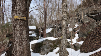
| The quarry is a tumble of rocks at the end of the Quarry Trail in the Palmer-Kendall Mountain Conservation Area in Tolland. |
I like to visit a variety of places because get bored by doing the same hike over and over. Some area I have hiked, I never return because I did not find them to be interesting enough to warrant a second visit.
The recommended places on this page I enjoyed enough that I have returned to them multiple times. These hikes are listed alphabetically by location name, not ranked by my preferences of which I think is a more desirable place to hike.
The description of what makes a location an above-average place to hike can be found on the page Characteristics of a Good Hiking Area: https://westrocktrails.blogspot.com/p/blog-page_20.html
As I add hikes to this page, some of the trails described in this guide may be Blue-Blazed Trails managed by the Connecticut Forest and Park Association (CFPA). The CFPA has an interactive map on its website that allows hikers to see an overview of the entire trail system with information about trail length and parking. Support CFPA by becoming a member because the trails don’t maintain themselves; the volunteers (with some help from a small staff and a summer trails crew) keeps the trails in good shape.
Interactive map: https://www.ctwoodlands.org/blue-blazed-hiking-trails/blue-blazed-hiking-trails-interactive-map
For other hiking areas managed by private organizations, pick one to support, so they can keep their trails maintained.
For state parks and forests, encourage the governor and your state representative and senator to properly fund state parks and forests (which are chronically underfunded and understaffed). You can also join the Friends of Connecticut State Parks, which advocates for the state parks, and, if one exists, a friends group for your favorite state park. Website: https://friendsctstateparks.org
For any of these areas, help out by becoming a trail maintainer yourself.
Be Bear Aware
Bears are an increasing presence in Connecticut, so no matter where you hike, be bear aware.
The DEEP has an entire page devoted to bear information: https://portal.ct.gov/DEEP/Wildlife/Nuisance-Wildlife/Living-with-Black-Bears
Disclaimer: The information presented here was believed to be accurate at the time it was posted in March 2022. Trails can change over time, including being closed, relocated, and blazed a different color. The website links were checked and working in March 2022. It is reasonable to assume that as organizations continue to update websites, links will change and old web addresses will not work. If a link does not work, just do a search for that trail or property to locate the current website.
Palmer-Kendall Mountain and Schindler-Schmidt Conservation Areas
· Why you should go: The 74-acre Palmer-Kendall Mountain and the 123-acre Schindler-Schmidt Conservation Areas are two nearly adjacent preserves on opposite sides of Kendall Mountain Road in Tolland. Palmer-Kendall Mountain is the more interesting of the two properties with extensive numbers of hemlock trees, two brooks, and a rocky area called the quarry where large slab of rocks are piled on each other, having broken away from the hillside. Schindler-Schmidt is a quiet and pleasant mostly hardwood forest with a small brook at the southeastern corner of the property. Both properties have some impressively tall trees, which might be 100 feet tall or taller.
· Starting Location/Parking: The dirt parking area for the Palmer-Kendall Mountain has an approximate address of 54 Kendall Mountain Road, Tolland, and has room for maybe four cars. There is no room along this narrow road for additional parking.
The preferred parking location is along the shoulder by the trailhead at 129 Wildwood Road, Tolland, which is a paved road. There is parking for as many cars can fit along the road, providing room for easily 20 cars. The minor disadvantage for this location is a climb of about 120 feet from Kendall Mountain Road to the high point before descending to the road.
The dirt parking area for the Schindler-Schmidt property has an approximate address of 330 Sugar Hill Road and has room for two cars. There is no room along the narrow road to park any additional cars.
· Directions to 129 Wildwood Road: I-84 East, Exit 68. Left on Rt. 195 North for 0.8 miles, which becomes Rt. 74 West. Bear right on Tolland Green Rd. for 0.2 miles, then straight on Old Stafford Rd. for 2.1 miles. Left on Cook Rd. for 0.9 miles. Right on Wildwood Rd. for 0.7 miles. Park along the woods on the left side.
I-84 West, Exit 69, then right on Rt. 74 West, and immediately turn right on North River Rd. for 0.1 miles. Left on Buff Cap Rd. for 1.8 miles. Left on Slater Rd. for 1.2 miles. Right on Stafford Rd. for 0.1 miles. Left on Cook Rd. for 0.9 miles. Right on Wildwood Rd. for 0.7 miles. Park along the woods on the left side.
· Map link: https://www.tolland.org/open-space-hiking-trails
· Trail Descriptions: Trails in the Palmer-Kendall area have both names and colors, while the trails in the Schindler-Schmidt area just have colors, excepting the Stream Trail, which is blazed Yellow-Black. The trails pass over rolling to hilly terrain with a 200-foot elevation gain between the lowest point in the Schindler-Schmidt area and the highest point in the Palmer-Kendall area. Footing is generally good throughout. The trails are clearly blazed and well maintained. In the Palmer-Kendall property, there is no connection between the Ridge Trail (Blue) on top of the ridge and the Quarry Trail (Yellow) to the quarry because of the tumble of rocks down a steep slope between the two trails. In the Schindler-Schmidt area, the Yellow-Red Trail is quite steep, rising 75 feet in only 0.15 miles. The Yellow-Blue Trail is almost as steep, rising the same distance over 0.2 miles. The two properties are connected by Kendall Mountain Road, a quiet dirt road open to traffic.
· Suggested Hike: From the south side of Wildwood Road, go straight on the Red Trail. At mile 0.2, turn right on the Loop Trail (Orange). At mile 0.5, turn right on the Ridge Trail (Blue) to the end and return. There is a screened and limited view from the end to the nearby road and houses. After completing the Ridge Trail (Blue) turn right on the Loop Trail (Orange) at mile 1.0, and almost immediately right again to stay on the west side of the loop (don’t cross the stream). At mile 1.3, turn right on the Quarry Trail (Yellow) to view the quarry and return. After completing the Quarry Trail (Yellow), turn right on the Orange Trail heading south at mile 1.6. The Loop Trail (Orange) also goes left and north. At mile 1.7, turn right on the Orange-Black Trail heading south (shown as Orange on the map from 2016): The Loop Trail (Orange) goes left and north.
Turn right on Kendall Mountain Road (dirt) at mile 1.75. At mile 2, turn left on the White Trail in Schindler-Schmidt Conservation Area. At mile 2.4, turn right on the Yellow Trail at split where the Yellow Trail also goes left. At mile 2.9, turn left on the Yellow Trail: the Yellow Trail also goes right out to Sugar Hill Rd. At mile 3, continue straight on the Stream Trail (Yellow-Black) to the end of the property and return. After returning, turn right on the Yellow Trail at mile 3.5. At mile 3.7, turn left on the Yellow-Red Trail for a short, steep climb. At mile 3.9, continue straight on the Yellow-Blue Trail: the Yellow-Blue Trail also goes right. At mile 4.3, turn left on the Yellow Trail at a T-int. At mile 4.7, continue straight on the Yellow Trail past the Yellow-Red Trail on left, then the Yellow-Blue Trail on the left. At mile 5.0, go straight on the White Trail.
At mile 5.4, turn right on Kendall Mountain Road (dirt). At the Palmer-Kendall Mountain property, turn left at mile 5.6 on the Loop Trail (Orange-Black). Almost immediately, turn right on the Loop Trail (Orange) at the split where Loop Trail (Orange) also goes left (You came from this direction at mile 1.7). Right at mile 6.0 to stay on the Loop Trail (Orange). Do not cross the bridge over the stream by the bench. At mile 6.2, continue straight on the Red Trail, arriving back at Wildwood Road at mile 6.5.
Shorter Options: There are many options to shorten this hike. Skipping the Ridge Trail (Blue) and the Quarry Trail (Yellow) is not recommended, as both trails are short and have scenic highlights. Hiking only the Palmer-Kendall Mountain loop using these notes yields a hike of 3.9 miles with 320 feet of climbing. These notes have a partial double loop in the Schindler-Schmidt area. Eliminating the loop up the steep hill shortens the hike by about 1 mile and saves 140 feet of elevation gain.
· GPS track: This 6.5 mile loop has 800 feet of elevation gain. The high point is 950 ft. of elevation at mile 0.15 and 6.30. The low point is 750 ft. of elev. at mile 3.30. https://connect.garmin.com/modern/activity/8409305665
· Safety concerns: None.
· Special considerations: Another nearby property is the 33-acre Crystal Peat Conservation Area, which has a 3 car dirt parking area at 172 Cook Road, Tolland, located 0.6 miles southeast of the Wildwood Road trailhead. The trails are mostly uninteresting, muddy woods roads. There are significant numbers of invasive plants along them. Hiking all the trails yields a loop of about 2 miles. Much of the property is wetlands with a small pond. There is no compelling reason to visit this property. The small black squares on the map indicate the placement of cement blocks.
· Future Hike: The other set of adjacent properties in Tolland is the Knofla, Campbell’s Peaceful Valley, and the Stoppleworth Conservation Areas. I plan to hike these in fall 2022, and if I like them well enough to add them to this page, I will do so following that hike. A hiking friend said they are pretty places to hike. For those who wish to hike those areas, this is some basic information:
Maps are available from the website using the link listed above. Park along the street by 14 Cortland Drive, Tolland. To start the hike, cross Bakos Road to the Loop Trail (Yellow) in the Knofla Conservation area. The hike features views of the Connecticut River Valley and Mount Tom in Massachusetts. This 7.5 mile loop has about 900 feet of elevation gain.
GPS track (not field tested): https://ridewithgps.com/routes/38666880
Directions: I-84 East, Exit 67. Left on Rt. 31 North for 0.4 miles. Right on Rt. 30 North for 1.6 miles (which briefly overlaps Rt. 74 East). Left on Rt. 30 North (leaving Rt. 74 East) for 2 miles. Right on Hunter Rd. for 0.2 miles, then left on Hunter Rd. for 0.6 miles. Right on Bakos Rd. for 0.2 miles. Right on Cortland Drive. Park on before the driveway for 14 Cortland Drive to give others room to park along the road.
I-84 West, Exit 68, then right on Rt. 195 North for 0.6 miles, which becomes Rt. 74 West and stay on Rt. 74 West for 0.7 miles. Turn right on Burbank Rd. for 0.6 miles, then right on Peter Green Rd. for 1 mile. Straight on Hunter Rd. for 0.6 miles. Right on Bakos Rd. for 0.2 miles. Right on Cortland Drive. Park before the driveway for 14 Cortland Drive to give others room to park along the road.
No comments:
Post a Comment