
 |
The Pequonock River flows past the old dam near Indian Ledge Road in the Pequonnock River Valley in Trumbull in April 2020. |
I like to visit a variety of places because get bored by doing the same hike over and over. Some area I have hiked, I never return because I did not find them to be interesting enough to warrant a second visit.
The recommended places on this page I enjoyed enough that I have returned to them multiple times. These hikes are listed alphabetically by location name, not ranked by my preferences of which I think is a more desirable place to hike.
The description of what makes a location an above-average place to hike can be found on the page Characteristics of a Good Hiking Area: https://westrocktrails.blogspot.com/p/blog-page_20.html
Further down on the page is a newer section labeled Honorable Mention. Any of those hiking areas would provide a pleasant experience, but are not as interesting as those listed at the top. My suggestion would be start with the hikes at the top of the page and once you have hiked all of them, try the other locations. Even though they may lack of some the features of the better hiking area, there is still a level of interest experienced by hiking somewhere you have never hiked.
Some of the trails described in this guide are Blue-Blazed Trails managed by the Connecticut Forest and Park Association (CFPA). The CFPA has an interactive map on its website that allows hikers to see an overview of the entire trail system with information about trail length and parking. Support CFPA by becoming a member because the trails don’t maintain themselves; the volunteers (with some help from a small staff and a summer trails crew) keeps the trails in good shape.
Interactive map: https://www.ctwoodlands.org/blue-blazed-hiking-trails/blue-blazed-hiking-trails-interactive-map
For other hiking areas managed by private organizations, pick one to support, so they can keep their trails maintained.
For state parks and forests, encourage the governor and your state representative and senator to properly fund state parks and forests (which are chronically underfunded and understaffed). You can also join the Friends of Connecticut State Parks, which advocates for the state parks, and, if one exists, a friends group for your favorite state park. Website: https://friendsctstateparks.org
For any of these areas, help out by becoming a trail maintainer yourself.
Disclaimer: The information presented here was believed to be accurate at the time it was posted in May 2020. Some hikes were posted later and that date may be noted in the description. Some links were updated at that time because the previous links had been changed and were no longer valid. It is reasonable to assume that as organizations continue to update websites, links will change and old web addresses will not work. If a link does not work, just do a search for that trail or property to locate the current website.
Scroll down to read the hike information:
· Bennett’s Pond State Park, Pine Mountain and the Hemlock Hills, Ridgefield; Wooster Mountain State Park, Danbury
Birch Rocks and Pratt Glen Preserves, Brookfield
· Collis P. Huntington State Park, Redding/Bethel/Newtown
· Hemlock Hills, Ridgefield
· Lillinonah Trail, Upper Paugussett State Forest, Newtown
· Paugussett Trail, Indian Well State Park and Birchbank Mountain
· Pequonnock River Valley, Trumbull
· Saugatuck Falls Natural Area, Redding
· Saugatuck Trail, Redding/Weston
· Seth Low Pierrepont State Park, Ridgefield
· Squantz Pond and the Pootatuck State Forest, New Fairfield
· Wilton Town Forest, Wilton
· Zoar Trail, Lower Paugussett State Forest, Newtown
Honorable Mention
- Devil’s Den, Weston
- Roosevelt Forest, Stratford
- Tarrywile Park, Danbury
- Trout Brook Valley, Easton and Weston
Fairfield County
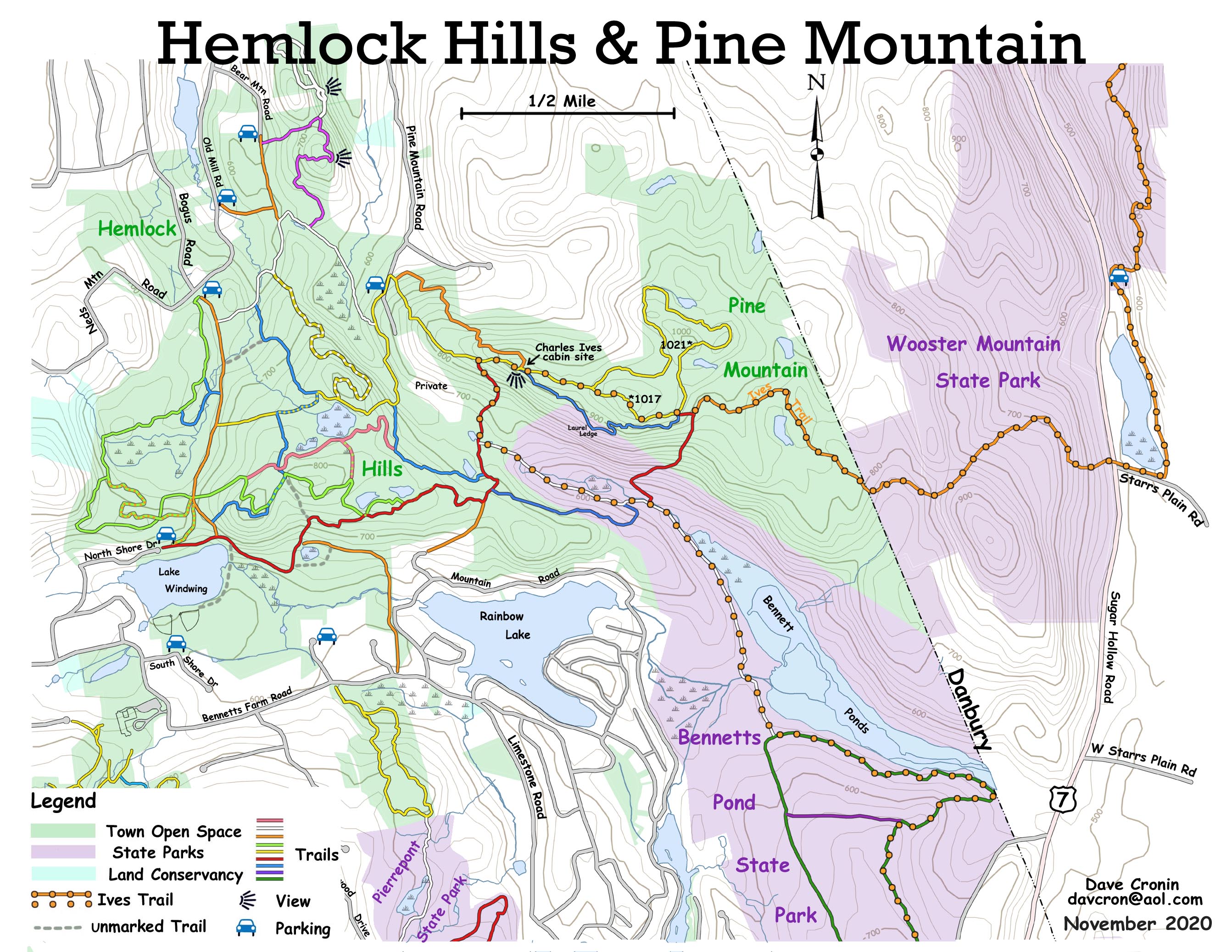
Bennett’s Pond State Park, Pine Mountain and the Hemlock Hills, Ridgefield; Wooster Mountain State Park, Danbury (added Feb. 2022)
· Why you should go: North of Bennetts Pond (the body of water) is a beautiful forest that is a mixture of hardwoods and hemlocks and is part of a large greenbelt area that includes the Hemlock Hills to the west. The pond itself is a pleasant area that is the foreground for views from the lower area north to the ridgeline. There is enough hiking in this area that other parts of the Hemlocks Hills are a separate hike further down this this list. This area feels remote because most trail segments are far from any roads. There is a good view from the Charles Ives cabin site on Pine Mountain.
· Starting Location/Parking: The entrance to Bennett’s Pond State Park is located at 599Bennetts Farm Road (across from 616 Bennetts Farm Rd.), Ridgefield. The gravel parking lot holds 15 cars.
· Directions: Rt. 15, Exit 40B to Rt. 7 North for 13.3 miles, left on Bennetts Farm Rd. for 0.7 miles, then right in the parking lot. I-84, Exit 3 to Rt. 7 South for 3.3 miles, right on Bennetts Farm Rd. for 0.7 miles, then right into the parking lot.
· Map links: Hemlock Hills, Pine Mountain map: https://www.ridgefieldct.org/sites/g/files/vyhlif4916/f/pages/hemlock_hills-pine_mountain_11_2020.jpg
Hemlock Hills, Pine Mountain map (full):
https://www.ridgefieldct.org/sites/g/files/vyhlif4916/f/uploads/major_hiking_trails_-_11x17_2019.pdf
Ives Trail map: https://ivestrail.org/ivestrail_map_2020.pdf
Bennett’s Pond State Park: https://portal.ct.gov/-/media/DEEP/stateparks/maps/BennettsPond.pdf
Bennett’s Pond/Hemlock Hills: https://hiking.waymarkedtrails.org/#routelist?relations=3924031,11974437
· Trail Descriptions: The state park is 460 acres in Ridgefield. Pine Mountain is 291 acres. Wooster Mountain State Park is 444 acres. The Hemlock Hills are 323 acres.
The Green Trail in Bennett’s Pond State Park, and the Blue and Yellow Trails at Hemlocks Hills are rolling to moderately hilly. The Orange Trail at Pine Mountain has some steep sections. The Red Trail from Bennett’s Pond to Pine Mountain is quite steep, as it ascends (or descends) the ridgeline between the two properties. The Ives Trail overlaps parts of these trails and is marked with a Red and Orange sign with a G-clef logo. The Waymarked Trails map (link above) has three trails north of Bennett’s Pond that are not official trails and blazes may be faded or non-existent. The Green Trail parallel to Route 7 is a winding single track trail that ascends the ridgeline gradually and safely, a much better alternative to the official Red trail.
· Suggested Hike: This 8.3 mile loop circles counterclockwise through these properties (with options to shorten to 7.3 or 6.8 miles). The full loop has about 1,300 feet of elevation gain. From the Bennett’s Pond parking lot, follow the Green Trail east, past the signboard where the Green Trail also goes left, passing through the remnants of a former estate. At mile 1.0 at the southeast corner of Bennetts Pond (the waterbody), continue straight where the official maps do not show the trail (which is visible on Waymarked Trails) and follow the 7-Up Trail (marked with faded Green blazes) up the ridge. The beginning sections pass close to Route 7 and have a fair amount of road noise, but that soon fades. At mile 2.2 turn left on the Ives Trail heading west. The Ives Trail passes various side trails and at mile 3.0, turn right on the Yellow Trail to follow the loop around Pine Mountain in a counterclockwise direction. (Skipping this loop saves 1 mile). At the end of the loop at mile 4.0, turn right on the Ives Trail/Yellow Trail continuing west. At mile 4.2, arrive at the site of the Charles Ives cabin, which has a good viewpoint to the south. Continue on the Yellow Trail west and descend to Pine Mountain Road. Turn left on the Yellow Trail along the road at mile 4.6 and the trail soon bears right away from the road, entering the Hemlock Hills. At mile 5.0, go straight on the Blue Trail by a large boulder, heading south, and then east. At mile 5.4, go briefly straight on the Red Trail, then left back onto the Blue Trail, heading east toward Bennett’s Pond. At mile 5.9, turn right on the White Diamond Trail/Ives Trail. At mile 6.4, turn left on the White Diamond Trail/Ives Trail and cross the stream on the footbridge. At mile 6.6, turn left on the Green Trail/Ives Trail heading east along the south side of Bennetts Pond (the waterbody). (Continuing straight at this point returns to the parking lot in 0.5 miles, but misses the walk along the pond). At the southeast corner of the pond at mile 7.2, turn right on the Green Trail/ives Trail. At mile 7.5, go straight on the Purple Trail heading west. Then at mile 7.8, turn left on the Green Trail and return to the parking lot on this wide woods road, arriving back at mile 8.3.
Shorter hike of 5.1 miles: Follow the above notes, but then at mile 4.3, just past the Ives cabin site, turn left on the Red Trail and descend very steeply. At the bottom, turn left on the White Diamond Trail/Ives Trail at mile 4.6. Continue straight on the Green Trail, arriving back at the parking lot at mile 5.1.
Bennett’s Pond only hike of 3.2 miles: This loop has an estimated 500 feet of elevation gain. From the Bennett’s Pond parking lot, follow the Green Trail east, past the signboard where the Green Trail also goes left, passing through the remnants of a former estate. At mile 1.1 at the northeast corner of Bennett’s Pond, turn left on the Yellow Trail. At mile 1.4, go straight on the unblazed trail along the north shore of the pond. At the northwest corner of the pond at mile 2.2, turn left on the White Diamond Trail/Ives Trail heading south. At mile 2.7, continue straight on the Green Trail, arriving back at the parking lot at mile 3.2.
· GPS track: None at this time.
· Safety concerns: The area is large with many trails, some of which are unblazed, and blazes on the marked trails are not always clear, so it is easy to get lost. Some trail sections are steep and caution is advised on these sections during wet, icy and snowy conditions. This particularly applies to the two Red Trail segments, which connect over the steep ridgeline from Bennett’s Pond (the water body) to Pine Mountain.
· Special considerations: Bennett’s Pond State Park south of the pond is completely overrun with invasive plants, including privet, winged euonymus, barberry, multi-flora rose, and bittersweet vines. It should serve as a warning as to how Connecticut woodlands will be destroyed over time unless these invasives are removed. For some reason, Bennett’s Pond has an apostrophe when referring to the state park, but has no apostrophe when talking about the pond.
Birch Rocks and Pratt Glen Preserves, Brookfield (added March 2022)
· Why You Should Go: Birch Rock and Pratt Glen Preserves are two names for a single open-space property of 175 acres located along the west bank of the Lake Lillinonah, a dammed section of the Housatonic River formed by the Shepaug Dam. In addition to views of the lake through the trees, there is also a pretty brook and groves of evergreen trees.
· Starting Location/Parking: There are two access point to the property. The official gravel parking lot with room for 10 to 12 cars is located at 40A Obtuse Rd. North, Brookfield. Streetside parking for as many cars as can park along the length of the road is available by the trailhead at 4 Ashwood Lane, Brookfield.
· Directions to Ashwood Lane: Rt. 15 North, Exit 46, then right on Jefferson St., and next right on Rt. 59 North for 8.2 miles. Left on Rt. 25 North for 7.5 miles. Right on Hanover Rd. for 1.1 miles. Left after RR bridge on Hanover Rd. for 2.3 miles. Left on Dinglebrook Lane for 0.7 miles. Straight on Obtuse Rocks Rd. for 1 mile. Left on Rt. 133 South for 0.5 miles. Right on Maple Tree Rd. for 0.2 miles. Left on Ashwood Lane for 0.1 miles. Park by the trail head located between 2 and 6 Ashwood Lane.
Rt. 15 South, Exit 49A to Rt. 25 North for 15 miles. Right on Hanover Rd. for 1.1 miles, then follow the above directions.
I-84 East or West, Exit 9 to Route 25 North for 0.9 miles. Right on Currituck Rd., then immediate left on Obtuse Rd. for 1.1 miles. Left to stay on Obtuse Rd. for 1.8 miles. Right on Rt. 133 North for 0.3 miles. Left on Maple Tree Rd. for 0.2 miles. Left on Ashwood Lane for 0.1 miles. Park by the trail head located between 2 and 6 Ashwood Lane.
To reach the parking lot at 40A Obtuse Road North: Follow the above directions from Route 15 (the Merritt Parkway), but instead of turning on Maple Tree Road, continue along 0.3 miles along Route 133, then turn right on Obtuse Rd. North for 0.6 miles, and the parking lot is on the right.
From I-84, follow the above directions, but don’t turn on Route 133. Instead, cross Route 133 onto Obtuse Road North and follow it for 0.6 miles to the parking lot on the right.
· Map https://ctland.org/our_trails/our-trails-detail/?otname=birchrocks · Trail Descriptions: The trails have rolling to hilly terrain with some short, steep sections. The Yellow Trail connects to the Red Trail by the lake, which is not shown on the map. The unnamed brook between the Red and Yellow Trails is pretty with some small cascades. Ashwood Lane is the high point at elevation 550 feet. The low point is the shores of Lake Lillinonah at elevation 220 feet. The Obtuse Road parking area is located at elevation 430 feet. The property is owned by the Northwest Connecticut Land Trust, formerly known as the Weantinoge Heritage Land Trust. Signs with the former name were still on the property in 2022. Rows of trees were knocked the ground by the May 15, 2018 macroburst, the same storm that devasted Sleeping Giant State Park and the Naugatuck State Forest, West Block, and Bent of River Sanctuary. The trails are fully open, looping around and through the damaged trees.
· Suggested Hike from Ashwood Lane: This 4 mile loop with 750 feet of elevation gain uses almost all the trail segments in the preserve. There is no kiosk at the road, but the trail is obvious as heads north. From the road, follow the Blue Trail for 0.8 miles and at the junction where the Blue Trail splits, turn right to head toward the lake. At mile 1, continue straight on the Yellow Trail. At mile 1.4 by the Red Trail, continue straight on the Yellow Trail following the brook. At mile 1.7, turn right on the Red Trail, cross the brook and bear left to follow the Red Trail loop clockwise. At mile 1.7. turn left on the Red Trail to a rocky viewpoint by the lake, and return to the brook. At mile 2, turn right to follow the Red Trail along the brook. By following this loop clockwise, hikers can view the brook in the uphill direction, which is more interesting than looking at it downstream. At mile 2.4, after crossing the brook, turn right on the Yellow Trail and follow this out to Obtuse Road North. At mile 2.6, turn left on the road and walk along the road and at mile 2.7, turn left into the parking area. Continue straight on the Yellow-Blue Trails and at mile 3, continue straight on the Blue Trail where the Yellow Trail turns left. At mile 3.4 turn right on the Blue Trail at the split where the Blue Trail also goes left toward the lake, arriving back at the parking lot at mile 4.0.
The last 0.6 miles of the hike rises 260 feet in elevation from a point near where the Blue Trail splits and goes in two directions (elevation 290 ft.) back to Ashwood Lane (elevation 550 ft.).
Shorter options: Skipping the Red Trail loop shortens the hike by 1 mile, but also misses the best views along the lake. Starting from the Obtuse Road parking area allows hikers to skip the Blue Trail to Ashwood Lane, which saves 1.5 miles and a 250 ft. gain in elevation.
· GPS track: None
· Safety concerns: There are some short, steep sections where the footing is a bit slippery. In particular, the Blue Trail 0.35 miles south of the T-intersection where it splits into two sections crosses a small ravine. The eastern side of the ravine has a notched log and a rope to provide additional traction and support.
· Special considerations: For those looking to hike more than 4 miles in the area, the nearest viable property is the 200-acre Williams Park, aka the Williams-Gurski Open Space, 185 Whisconier Road, Brookfield, located 2 miles away. However, Williams Park has little to recommend hiking there. The trails are lined with the invasive winged euonymus shrub, along with plenty of tick-loving Japanese barberry, standing as a powerful example of how these non-native plants can dominate and ruin Connecticut’s woods. The trails are wide, woods roads with frequently muddy footing. The only scenic part of the woods is a brief view of Merwin Brook along the Red Trail. The Red Trail loop, which is a circuit around the property, is 3 miles; note that the trail north of Merwin Brook was not blazed in 2022.
The nearest area is the 68-acre Lillinonah Woods with a potential 2-mile loop, but a Brookfield trail maintainer told me in 2022 that those trails were blocked by the 2018 macroburst and were never cleared.
The 25-acre Old Bridge Sanctuary, 57 Old Bridge Road, is another property along Lake Lillinonah with about a mile of trails.
These trails are listed in the Brookfield Trail Guide: https://www.brookfieldct.gov/sites/g/files/vyhlif341/f/uploads/trailguide2016.pdf
The nearest desirable hiking area is the Upper Paugusett State Forest with the Lillinonah Trail, which is described elsewhere on this page.
Collis P. Huntington State Park, Redding/Bethel/Newtown
· Why you should go: The 1,017-acre Huntington State Park offers a variety of carriage roads and trails that loop past bucolic ponds on the property that was once an estate. There are also small streams that wind their way through rocky ravines.
Near the north end of the park, explore the grounds of a former mica mine.
Although the official park name is Collis P. Huntington State Park, because it is named after railroad magnate Collis P. Huntington, users simply refer to it as Huntington State Park. His stepson, Archer M. Huntington (who died in 1955) and Archer’s wife, sculptor Anna Hyatt Huntington, lived on the property. The family donated the land for the park to the state, with the state taking ownership following her death in 1973. I can find no information online regarding what happened to the house, although portions of other structures may be seen.
At the main parking area, enjoy the bronze sculptures created and donated by Anna: “Mother Bear and Cubs” showing a mother bear and two cubs and a separate one “Sculpture of Wolves”, which displays two howling wolves. These sculptures are a change from her usual style, which often involves a dramatic situation of person with a horse.
· Starting Location/Parking: There are two primary locations for parking.
The main parking area is located at 76 Sunset Hill Road, Redding. As the more visible location, this parking area may fill up on good weather weekend days. This parking lot also has the disadvantage that your hike ends with an uphill walk, usually a windswept one.
One mile north of the Sunset Hill Road entrance, there are two parking lots are located near 10 Old Dodgingtown Road, Redding (also referred to as Dodgingtown Road). One parking lot is 0.2 miles on the right from Sunset Hill Rd. The other is at the end of the road, 0.4 miles from Sunset Hill Rd.
In addition, there are two small parking areas for no more than 3 cars each on and near the park’s eastern border. One is located on the west side of Hopewell Road in Newtown, just north of the border with Redding’s Hopewell Woods Road, 1.5 miles north of Route 58.
The other is for the Aspetuck Trail on the east side of Hopewell Road in Newtown, 1.8 miles north of Route 58.
· Directions to the Sunset Hill Road parking area. As you can see, getting to the park is complicated, so GPS is a helpful tool to find your way:
From the northwest: I-84, Exit 5 and follow Rt. 53 south for 3.4 miles. Left on Rt. 302 East for 1.6 miles. Right on Rt. 58 South for 1.3 miles, then left on Sunset Hill Rd. for 2.3 miles. The main entrance is on the left.
From the northeast: I-84, Exit 11, then left on Wasserman Way. Right on Route 25 North, then left on Route 302 West for 2.5 miles. Left on Key Rock Road for 0.9 miles. Straight on Poverty Hollow Rd. for 1.6 miles. Right on Hopewell Road (becomes Hopewell Woods Road in Redding) for 2 miles. Right on Rt. 58, then immediate right on Sunset Hill Rd. for 0.8 miles. Right into the main entrance parking lot.
From the southwest: Route 15 North, Exit 42 to Route 57 South for 0.2 miles, then left on Rt. 136 North for 5.2 miles. Right on Rt. 58 North for 7 miles, then right on Sunset Hill Rd. The main entrance is 0.8 miles on the right.
From the southeast: Route 15 South, Exit 44, to Rt. 58 North for 10.5 miles. Right on Sunset Hill Rd. for 0.8 miles. The main entrance is on the right.
· Directions to the Sunset Hill Road parking area: Follow the directions to the main parking area with these adjustments: If coming from the north, after the turn on Sunset Hill Road, turn left on Old Dodgingtown Road, 1.3 miles south of Route 58. If coming from Route 58 North, continue past the main entrance for 1 mile, then turn right onto Old Dodgingtown Road.
· Map link: Download a map and read about the park history at the state website: https://portal.ct.gov/DEEP/State-Parks/Parks/Collis-P-Huntington-State-Park
· Trail Descriptions: Most trails are wide carriage roads with gradual elevation changes. The definite exception terrain-wise are the Blue Trail and White Trail that follow the AT&T right of way west to east in the park’s Bethel section, which have very steep sections. The White Trail between East Lagoon and West Lagoon is a narrow footpath; near the base of the lagoon is a steep descent with potentially uncertain footing in slippery conditions.
The White Trail west of Lake Hopewell is a blazed single-track trail created by mountain bikers.
The Blue-Blazed Aspetuck Valley Trail connects to the park’s trail system from the east in Redding, near the Bethel and Newtown Border and links the park to the Saugatuck Trail at Black Road Turnpike (Route 58). Primarily in the Bethel section, there are numerous unmarked single-track trails that have been created by mountain bikers.
Intersections on blazed trails are sometimes marked with a letter or letters, which are not indicated on the trail maps. This limits their usefulness as waypoints. On the 2009 map, the White Trail past the South Pond is actually blazed Blue. I asked the state to update the map, but this request was not fulfilled.
· Suggested Hike: This 5.5-mile loop is the easiest hike to follow. Start at the Sunset Hill Road parking lot and descend the grassy hill to the bottom where the Blue Trail starts. Turn left on the Blue Trail and follow the loop clockwise around the park. The Blue Trail within the park is blazed a medium-dark blue, while the Aspetuck Valley Trail is blazed a sky blue color. The “White Trail” from Lake Hopewell to South Pond has been blazed blue for years, but the state map has not been updated to reflect this change.
For a shorter loop of 2.5 miles, after passing turning off the main north-south blue-blazed carriage road, turn right on the White Trail heading south along the west side of West Lagoon, and continue south along the Red Trail. At the next trail junction, continue south on the Blue Trail (incorrectly marked as White on the map). At the main carriage road past South Pond, turn left and then climb up the grassy slope back to the parking lot.
· GPS track: This track is for a 7.5-mile loop with 900 feet of elevation gain that covers most of the park.
· Track: https://connect.garmin.com/modern/activity/1655159482
· Safety concerns: The trails at Huntington can be confusing to follow and with many options, it is easy to get lost. Trail junctions are sometimes marked with letters, but since those letters are not listed on the state maps, they are not of much use unless someone writes the letters on their own map as they hike.
The right of way for AT&T at the northern end of the park on the Blue Trail and White Trail have some VERY steep sections that are slippery even in dry conditions due to all the loose rock.
Huntington is the rare state park where hunting is allowed, presumably to help reduce the size of the deer herd in Fairfield County. Archery only hunting is permitted from Sept. 15 to Dec. 31. Hunting is prohibited on Sundays in Connecticut.
· Special considerations: The area is popular with mountain bikers, so be alert to their presence. It is best to step aside to let them roll by, rather than forcing them to dismount while you walk by.
· Historical Information: There is a detailed park history on this website: http://historyofredding.net/HRhuntingtonpark.htm
· While in the area: Anna created other bronze sculptures of people on horses, which may be seen in Redding and nearby towns. While in town for the hike, go see these works of art. Just don’t visit school grounds while school is in session. She donated all of her works.
There is a statue in front of two public schools in Redding: “Fighting Stallions” at Redding Elementary School, 33 Lonetown Road (Route 107) and “A Tribute to the Work Horse” at John Read Middle School, 486 Redding Rd. (Route 53, plus “Torch Bearers” at the Mark Twain Library, 439 Redding Road (Route 53).
At the entrance to Putnam Memorial State Park on Route 58 at the junction with Route 107 is a sculpture shows a fist waving General Israel Putnam riding a horse charging down the stairs in Greenwich, escaping from pursuing British soldiers in 1779. The Putnam sculpture is located at Putnam Park. The park is certainly worth visiting for its historical value as the site of a 1779 encampment of the Continental Army, sometimes described as Connecticut’s Valley Forge. However, I have not included it as a list of recommended hiking areas because hiking is not its function. There are not any real trails at the park, just loop roads that are good for walking.
In nearby Bethel, find “Young Abe Lincoln on Horseback” by the Bethel Public Library, 189 Greenwood Ave. (Route 302), Bethel.
In Danbury, “Sybil Luddington” rides a horse in front of the Danbury Library, 170 Main St. (Route 53), Danbury. A larger version of Sybil rides along the shores of Lake Gleneida across from the school at 12 Gleneida Ave. (Route 52), Carmel, N.Y.
Hemlock Hills, Ridgefield
· Why You Should Go: The Hemlock Hills are part of a vast interconnected area of open space in Ridgefield, which includes Pine Mountain and Wooster Mountain (in Danbury) to the east, Bennetts Pond State Park to the southwest, and separated by a neighborhood, Pierrepont State Park and related Ridgefield open space properties to the south.
The Hemlock Hills property with 323 acres has a number of appealing features: a hemlock forest with the dappled light that creates a sense of mystery and wonder, craggy rock formations that the trails wander over and through, a walk along Lake Windwing (really a pond), and also marsh framed by hills. There are various babbling brooks, and a view to Danbury and the surrounding hills. Admittedly, the most visible feature in the view is the Danbury Fair Mall. Some impressive trail work has been done, including rock retaining walls and switchback curves on some trails. Overall, the area offers a little bit of everything.
· Starting Location/Parking: The Hemlock Hills and Pine Mountain map shows potential parking at seven different locations in Ridgefield. The parking areas in the northern part of the property are mostly pull-offs along a narrow road. There is room for about six cars at in the lot on Neds Mountain Road at the junction with Bogus Road. There is room for about five cars at the end of Pine Mountain Road.
There are three parking locations along the south side of the property. Whitlock Lane, which is not named on the map, has roadside parking. There are two parking areas by Lake Windwing, a five-car lot with an approximate address of 31 North Shore Drive, and an eight-car lot at 17 South Shore Drive near the baseball fields. If the gate to the ballfields is open, then there is the potential for more parking, but that also might mean less parking because of a ball game.
During non-school hours, there is plenty of parking at Ridgebury Elementary School, 112 Bennetts Farm Road, a short walk from the ballfields.
· Directions to the school: Rt. 15 South, Exit 42 to Route 57 North for 7.6 miles. Left on Rt. 107 for 0.3 miles. Right on Rt. 7 North for 4.5 miles. Left on Haviland Rd. for 1 mile. Right on Limestone Rd. for 2.2 miles. Straight on Bennetts Pond Rd. for 0.8 miles. Left into the school driveway after the sharp curve, then right into the parking lot.
Rt. 15 North, Exit 38 to Route 123 North for 10.6 miles. Right on Rt. 35 for 2 miles. Left on Rt. 33/35 North for 0.9 miles. Bear right on Rt. 35 North for 1.6 miles. Left on Limestone Rd. for 2.2 miles. Straight on Bennetts Pond Rd. for 0.8 miles. Left into the school driveway after the sharp curve, then right into the parking lot.
I-84 East or West, Exit 1 to Saw Mill Road heading south for 1 mile. Bear left on Turner St. for 0.4 miles. Straight on Ridgebury Rd. for 1.9 miles. Left on Old Stagecoach Rd. for 0.8 miles. Left on Bennetts Farm Rd. for 0.5 miles. Right into the school.
· Directions to the ballfields: From Rt. 15, instead of turning left into the school, continue another 0.1 miles, then right on South Shore Drive, then left into the ballfields parking area. From I-84, turn left on South Shore Drive, 0.1 miles before the school, then left into the ballfields parking area.
· Maps link: https://www.ridgefieldct.org/sites/g/files/vyhlif4916/f/pages/hemlock_hills-pine_mountain_11_2020.jpg
Hemlock Hills, Pine Mountain map (full):
https://www.ridgefieldct.org/sites/g/files/vyhlif4916/f/uploads/major_hiking_trails_-_11x17_2019.pdf
· Trail Descriptions: Trails are well maintained and well-marked. There are some short, unblazed trail sections. Colors can be confusing where two trails overlap for brief sections. Most trails are footpaths, but a couple are wide woods roads. Footing is generally solid, but some hilly sections have slippery spots, particularly if they are wet or muddy. Expect plenty of climbs and descents in this hilly area.
· Suggested Hike: This 8-mile hike has 1,400 feet of elevation gain and matches the GPS track. The hike can easily be started from the South Shore Drive parking lot, just subtract 0.2 miles from the following mileages.
From Ridgebury Elementary School, turn left and follow the sidewalk north along Bennetts Farm Road, then turn right and walk along the shoulder of South Shore Drive, then left into the driveway to the ballfields.
Turn right at mile 0.3 and follow the path through the grassy field south of Lake Windwing, then turning left to follow its east shore. At mile 0.5 in the woods, turn left on the Red Trail, then right at mile 0.7 on the Green-Orange Trail, then left on the Green Trail at mile 0.8. At the Orange Trail at mile 2, turn right, then next left at mile 2.1 on the White Trail. At mile 2.5, continue straight on the Orange Trail where the White Trail turns right, then at mile 2.7, right on the Lavender Trail, then left on the White Trail to the viewpoint facing east toward the Danbury Fair Mall. Continue on the loop in a counterclockwise direction.
Arriving back at the Lavender Trail at mile 3.2, then continue straight and soon loop past a second viewpoint of the nearby hills. Left at mile 3.9 on the White Trail, then right on the Yellow Trail at mile 4.2, staying on Yellow as it swings west by the Blue Trail. At mile 4.7, right on the Blue Trail heading north where the Yellow-Blue Trail goes left. At mile 5.0, left on the White Trail, then left at mile 5.1 on the Orange Trail, then left on the Green Trail at mile 5.5.
Where the Green Trail turns south, continue straight on the Pink Trail at mile 5.7. The second time you come to the Blue Trail, turn right at mile 6.3, then straight on the Red Trail at mile 6.6 (Red and Blue briefly overlap). At mile 6.7, bear right on the Red Trail where it swings west. Back at Lake Windwing at mile 7.5, turn left and follow the grassy path along the east shore, and then right along the south shore of the lake. Turn left and walk through the parking area, then right on South Shore Drive, then left on the sidewalk along Bennetts Farm Road, then right into the Ridgebury School parking lot, arriving back at mile 8.0.
6-mile hike with 1,100 ft. of elevation gain: At mile 5.5, don’t turn left on the Green Trail; instead, continue straight on the Orange Trail, then turn left on the Red Trail along the north shore of Lake Windwing. Then turn right to enter the grassy field and follow the east, then south shore of the lake. Back at the parking area, follow the above notes to return to the school. (Or if you started at the ballfield parking area, you are done).
4.5-mile hike with 700 ft. of elevation gain (which also misses the viewpoints): At mile 2.5, turn right on the White Trail instead of continuing straight on the Orange Trail. As you pass the Lavender Trail, you pick up the longer hikes at mile 3.9. This loop assumes you follow the notes for the 6-mile hike, turning left on the Green Trail, which will be mile 4.0 for you.
· GPS track: This 8-mile hike with https://connect.garmin.com/modern/activity/8543238596
· Safety concerns: Some of the trails have steep sections, so caution is advised in slippery conditions.
· Special considerations: Those looking for a much longer hike could continue east into Pine Mountain, the south into Bennetts Pond State Park. For most people, these other areas are an opportunity to hike the town on a different day.
Lillinonah Trail, Upper Paugussett State Forest, Newtown
· Why you should go: The Blue-Blazed Lillinonah Trail is located in the Upper Paugussett State Forest and winds through through a hemlock forest and rock formations adjacent to Lake Lillinonah, a 1,900-acre lake formed on the Housatonic River by the Shepaug Dam. About half of the hike is along the lake and Pond Brook, an inlet to the lake. The Upper Gussy Trail and Brody Road can be used to make a loop if you do not wish to do the entire Lillinonah Trail circuit.
· Starting Location/Parking: There is a dirt parking lot at the Pond Brook Boat Launch, 160 Hanover Rd., Newtown. The area can easily hold 30 cars.
· Directions: I-84 Exit 10 to Rt. 6 W. for 0.6 miles. Right on The Boulevard (becomes Hanover Rd.) for 3.4 miles. The parking area is on the right.
· Map link: Upper Paugussett State Forest map: https://portal.ct.gov/-/media/DEEP/stateparks/maps/Pagussettpdf.pdf?la=en
· The Lillinonah Trail is a Blue-Blazed Trail managed by the Connecticut Forest and Park Association (CFPA) with information and map available in the Connecticut Walk Book (West).
· Trail Description: The Lillinonah Trail is 6.5 miles long, and winds up and down many climbs and ascents totaling 1,200 feet of elevation gain.
Suggested Hike: Starting from the Pond Brook parking area, turn left on Hanover Road. The blue trail markings are on the left in about 0.1 miles. Follow the markings in your choice of direction, clockwise or counterclockwise, to complete the loop. Pay careful attention to these trail markings as the trail sometimes follows wide woods roads, before turning off onto a narrower footpath. When you reach Hanover Road from the end of the trail, turn right to return to the parking area. You can use the Brody Road (a dirt woods road) or the Upper Gussy Trail to create shorter loops.
· GPS track: This track is for the 6.4-mile loop on the Lillinonah Trail with 960 feet of elevation gain. https://connect.garmin.com/modern/activity/981271395
· Safety concerns: A few portions of the trail have short, steep climbs, so this trail is best used in dry conditions for maximum traction. Hunting is permitted, so wear blaze orange during hunting season (primarily September to December), or hike on Sundays when hunting is not permitted.
· Special considerations: There are other trails and woods roads within the state forest. Pay careful attention to the blazes as the trail crosses and sometimes follows woods roads. Along the way, you may see other markers for Al's Trail, a trail that passes through the forest. The most scenic part of the trail is closed from Dec. 15 to March 15 to allow eagles to nest. During the warmer months, typically May to September, the lake is used by boaters, so you will hear boat engines at these times. Lake Lillinonah gets much less powerboat traffic than Lake Zoar.
Paugussett Trail, Indian Well State Park and Birchbank Mountain Open Space, Shelton
· Why you should go: The 14-mile long Paugussett Trail has several distinct sections: in Monroe from East Village Road to the Blue-Yellow Connector Trail to Route 34; from the Connector Trail to Webb Mountain Park; the White Hills streets and woods of Shelton; Birchbank Mountain and Indian Well State Park, and from Route 110 to Buddington Road in Shelton. This last section includes the Shelton Recreation Trails network by Shelton High School and Shelton Intermediate School. The Webb Mountain section is discussed on this webpage under Webb Mountain Park in Monroe.
This hike focuses on the portion within and near Indian Well State Park in Shelton, and the adjacent Birchbank Mountain Open Space area, which parallels the Housatonic River. This section has rugged rock formations, including an extended rock scramble, two views of the Lake Housatonic section of the Housatonic River, and, on the Birchbank Mountain property’s White Trail, a hike along the Upper White Hills Brook, which has some small cascades. Within the state park is Indian Well, a waterfall with a small basin or well at the bottom.
· Starting Location/Parking: Use the first parking area at Indian Well State Park, 45 Indian Well Rd., Shelton, which has room for about 15 cars. The state has been closing this parking area at times. Additional parking for about 5 cars is available in a small parking lot by the railroad tracks on the road heading to the houses. There is also a small trailhead for maybe 8 cars at the base of the White Trail that is always open. All these parking areas are free year round.
The main parking area for the park past the booth charges a fee in summer for vehicles without Connecticut license plates. The main parking area is closed from Oct. 1 to April 1. This parking area is also likely to be full on a warm weekend day in summer.
· Directions: Rt. 8, Exit 14 to Rt. 110 North for 2.2 miles. Right into Indian Well State Park and drive 0.3 miles. Right into parking area just past Maples Road, or park in the "off-season" parking area near the railroad tracks on the road leads to the neighborhood called The Maples by the sign "Indian Well Road” if the parking lot gate is locked.
· Map links:
The Indian Well State Park from 2016 is outdated. It does not show the trail updates that are on the Shelton Conservation Commission maps, but does show the entire trail in the park that leads to the Birchbank Mountain Open Space. https://portal.ct.gov/DEEP/State-Parks/Parks/Indian-Well-State-Park
Use the Shelton Conservation map link for the Indian Well area:
http://www.sheltonconservation.org/recreation/maps/Tahmore%20and%20Indian%20Well%20Trails%20May%202020.pdf
This map says the bridge on Indian Well Road is closed to pedestrians due to construction in 2020, but the construction has been completed and the bridge is open to pedestrians. Be VERY careful crossing the bridge because the road is narrow, sightlines are limited, and cars come quickly around the bend.
Birchbank Mountain Open Space: http://www.sheltonconservation.org/recreation/maps/Birchbank%202018%20Trail%20Map%20for%20Printing%20PDF.pdf
The following 2016 map from the Shelton Conservation Commission provide a good overview of the entire trail, but does not show some of the updates within Indian Well, including the Blue-Red Beach Cutoff Trail seen on the Tahmore Map from 2020, and the modest change in the western part of the Tahmore Loop: http://www.sheltonconservation.org/recreation/maps/Paugusset%20Trail%202016.pdf
· Trail Descriptions: The Paugussett Trail (Blue) is rugged with uneven footing, a rock scramble, and about five brooks to cross on rocks. The Blue-Yellow Trail on the Tahmore Property has moderate climbs with good footing. The Blue-Red Beach Cutoff Trail is a narrow trail that parallels the hillside. The White Trail on the Birchbank Road property is a steady descent from west to east with good footing and a couple of short, steep sections.
· Suggested Hike: This hike is about 7 miles long.
From the parking area, cross Indian Well Road and follow the Falls Trail to Indian Well (the waterfall). On the return, turn left to cross Indian Hole Brook on the Blue-Blazed Paugussett Trail. This crossing may be difficult or impossible at times of high water, so cross on the road bridge at those times. The Blue Trail then switchbacks up the hill, passing the Blue-Red Beach Cutoff Trail, and later the two trails briefly overlap. At the junction with the Blue-Yellow Tahmore Trail, take the left fork past the viewpoint to complete the loop clockwise. Back at the Blue Trail, turn left to continue north. Pass the White Trail, which descends to the road via a set of stairs. Navigate the rock scramble on the Birchbank Mountain property. Beyond the scramble, stay on the Blue Trail, as you pass the Blue-White Trail on the right. At the junction with the White Trail by the brook, turn left to head uphill and complete the White loop clockwise. Past the base of the cascades, continue straight on the White Trail, and at the next junction where the White Trail goes straight to the trailhead at Birchbank Road, turn sharply right to stay on the White Trail loop heading back toward the brook.
Midway up the hill, turn left on the Blue-White Trail to return to the Paugussett Trail heading south. Backtrack on the Paugussett Trail past the rock scramble to return to Indian Well Park. Within Indian Well, turn left on the White Trail and descend the stairs. Right on the Blue-Red Beach Cut-Off Trail. Where the Blue-Red Trail overlaps the Blue Trail, bear left to stay on the Blue-Red Trail. At the end of the Blue-Red Trail, turn left on the Paugussett Trail to descend to Indian Hole Brook. Cross the brook on the rocks (if possible) or use the road bridge if the brook is running too high. The Bypass Trail to the road is on the left just before the brook crossing. After crossing the brook, turn left to return to the parking lot.
For a longer hike: Follow the Paugussett Trail past the White Trail at Birchbank and turn around at Round Hill Road. Beyond this point, the trail loops through backyards in the White Hills neighborhood and is not very appealing. This adds 1 mile to your hike
For a shorter hike: Skip the loop on the Tahmore Trail (saving 0.9 miles of hiking), the White Trail loop at Birchbank Mountain (saving 1 mile of hiking), and/or turn around earlier on the Paugussett Trail.
· GPS track: To be added at a later date
· Safety concerns: The trail has some steep sections, along with the rock scramble that are a challenging in snowy and icy conditions. While it would be tempting to return on Indian Well Road to make this more of a loop hike, the road is dangerous for walking because is narrow with no shoulder and the hills and sharp curves make it difficult for motorists to see hikers. Crossing Indian Well Brook is a challenge on the rocks and on the Indian Well Road bridge, there is no shoulder. Swimming is prohibited in the waterfall basin.
· Special considerations: Thanks to Teresa Gallagher, the Shelton Conservation Officer, and her husband Terrence, and all their volunteers for truly transforming the Paugusssett Trail into an enjoyable hiking experience.
Pequonnock River Valley, Trumbull
· Why you should go: The Pequonnock River Valley is a beautiful property along the Pequonnock River with hemlock-lined trails set against a backdrop of rock formations. The western side of the river offers an easy loop along a well-groomed stone dust surface rail trail that is 2.5 miles from Tait Road to Whitney Avenue. You can extend your walk (or ride) to 3.5 miles by continuing through Parlor Rock Park and Old Mine Park in Trumbull. The rail trail is 10 miles long, passing through Monroe and ending in Newtown, but there are several on-road sections in Monroe. The eastern side of the valley has trails that are mostly flat along the river with some mild inclines as you get closer to Route 25. Footing is good in all four seasons, although some of the flatter trails may ice over in winter and early spring.
· Starting Location/Parking: There are three parking areas for the Pequonnock River Valley. Two parking areas provide direct access to the Housatonic Rail Trail. One parking area is on Tait Road, off Route 127 (Church Hill Road/White Plains Road). The other parking area is off Whitney Avenue, east of Main Street (Route 111). The Tait Road parking area is frequently full with cars parked along the length of the road. The Whitney Avenue parking lot is small (maybe 5 to 7 cars) and may not have any room available on a busy weekend. There is no street parking available on Whitney Avenue. The Pequonnock River Valley is adjacent to Indian Ledge Park, a Trumbull town park. If you do not have a current Trumbull parking sticker (available only to residents) and you park at Indian Ledge, the Trumbull park ranger will surely find your car and issue a parking ticket. The commonly-used parking area for the east side of the Pequonnock River is the state Park and Ride lot (aka commuter parking lot) at 50 Park St., off Route 25, Exit 9. The east side of the river is where all the trails are located.
· Directions: For the Park and Ride: Take I-95 Exit 27A (Rt. 25 North) or Merritt Pkwy. Exit 49 (Rt. 25 North). Rt. 25 to Exit 9 (Daniels Farm Road). Left onto Daniels Farm Rd. at light, then next right onto Park St. CPL will be on the left. From I-84, take Exit 9 (Rt. 25 South). At Rt. 111, Rt. 25 becomes a six-lane highway. Get off at Exit 9 (Daniels Farm Road.). The CPL will be opposite the exit ramp. For the rail trail parking at 10 Tait Road, follow the directions to the Park and Ride (with these changes). From Rt. 25 North, turn left onto Daniels Farm Road, then right onto Church Hill Rd. (Rt. 127), and right onto Tait Road. From Rt. 25 South, turn left onto Park Street, right onto Daniels Farm Road, then right onto Church Hill Rd. (Rt. 127), and right onto Tait Road.
· Map link: The Pequonnock River Valley is owned 60 percent by the state and 40 percent by the town, which means it can fall between the cracks with regard to any maintenance. There is no official state or local map for the property. However, Rich Coffey, a dedicated mountain biker did some valued trail work in the property and created this map: http://vizettes.com/pequonnockvalley/maps/index.htm
Be sure to click through this website to view the information Rich has posted about the Valley and the nearby Parlor Rock Park and Old Mine Park. He has a link to a guide to the historic sites in the Valley that I compiled and annotated from previously published guides:
http://vizettes.com/pequonnockvalley/misc/index.htm
· GPS track: This is a 6-mile loop on the eastern side of the Pequonnock River with a mild 550 feet of elevation gain: http://connect.garmin.com/modern/activity/66999252
· Trail Descriptions: The White Trail is a wide, mostly flat woods road that runs the length of the property. The Blue Trail is a narrow single track trail with lots of roots, and it follows the river. The Red Trail and the Yellow Trail have some modest climbs. You may hear road noise on the Red and Yellow Trails as they are close to Route 25.
· Suggested Hike: Starting from the Park Street lot, turn left on Park Street. At the cul-de-sac, turn left into the forest. You have to cross the stream on rocks, which is not always easy to do. (If the water is particularly high, turn right and follow the stream upstream and cross further up where it is narrower.) After crossing the stream, turn right on the White Trail and then right again on the Red Trail. The Red Trail and the Yellow Trail intertwine, so you can follow one, the other or both, which eventually merge back with the White Trail near Indian Ledge Park. Follow the White Trail to Indian Ledge Park where you can find some picnic tables to eat your lunch. Take the Blue Trail south, which connects off the White Trail. The Blue Trail parallels the river and eventually merges back with the White Trail. Follow the White Trail out to the stream crossing and Park Street. Expect that you may get turned around as trail markings are not always consistent, especially in the area of the old reservoir bed where there are few trees to blaze.
· Safety concerns: The Valley east of the Pequonnock River is open to hunting from October to December on Tuesdays, Thursdays, Fridays, and Saturdays. The area is so well used by mountain bikers and hikers that I doubt many hunters are in the woods, but wear blaze orange just in case.
· Special considerations: The rail trail and the single-track trails east of the river are VERY popular with mountain bikers, so be aware that they may appear without warning. There are many unmarked trails in the valley, so pay careful attention to the trail blazes, as it is easy to get lost. You cannot get too lost as you are bordered by the river on the west and Route 25 on the west. Some trails are low-lying and may be muddy portions of the year, so wear waterproof boots. Entering the property from Park Street, you have to cross a stream that is about 20 feet wide on the rocks, as there is no bridge. You cannot easily create a loop using the rail trail and the trails east of the river, due to a lack of bridges. You could hike the regular trails out to Indian Ledge Park, turn left and walk on Whitney Avenue (which is narrow with no sidewalk) to the rail trail, and turn left on the rail trail to return south, but then you have an uphill walk along busy Daniels Farm Road (with a sidewalk) to return to the Park Street lot. In 2024, beavers have built some low dams in the plains area between one to one and a half miles north of Park Street that have flooded the Blue Trail in this area. Follow the White Trail to the west of the Blue Trail to stay out of the flooded area. This trail may be passable at times of little rain.
 |
A beaver dam adjacent to the boardwalk along the Pequonnock River Valley's Blue Trail, 1.6 miles north of Park Street, has flooded the trail. Another nearby section of boardwalk was under water the day this photo was taken on Dec. 31, 2024. |
Saugatuck Falls Natural Area, Redding
· Why you should go: Saugatuck Falls is the highlight of this 312 acre property that has the Saugatuck River crossing along its south side. There are also stands of hemlocks and mixed hardwood forests along its slopes. The powerline corridor cutting through it is blanketed with mountain laurel and other native shrubs. This is the Redding Land Trust’s most popular preserve.
· Starting Location/Parking: Meet at John Read Middle School, 486 Redding Rd. (Rt. 53), Redding, one mile north of Rt. 107. If you go during school hours, there are a couple of parking spaces by the preserve entrance on the east side of Route 53.
· Directions: Rt. 15 South to Exit 44. Take Rt. 58 North for 10 miles. Left on Cross Highway by the church and go 2 miles. Straight on Rt. 107 South at the stop sign (by the Redding Nursery). Go 1 mile. Right on Rt. 53 North for 0.75 miles. Right into John Read Middle School. Rt. 15 North Exit 42 to Rt. 57 North to Rt. 53 North. The school is on the right 0.75 miles north of Rt. 107. I-84 Exit 5 to Rt. 53 South. The school is on the left 2.7 miles south of the Bethel-Redding border.
The preserve is directly across the street from the school. Total elevation gain is 700 ft. of climbing. Numbers here correspond to the map, which may be found in the Redding Land Trust’s The Book of Trails IV. The book may be purchased in the Mark Twain Library on Rt. 53, just north of Rt. 107. The price is $10. Hike overview at http://ridewithgps.com/trips/4071886
· Map link: https://reddingctlandtrust.org/saugatuck-falls
· Trail Descriptions: Redding uses its own system of blazing trails. Most trails are blazed White and short connector trails are blazed Blue. Junctions may be marked with wooden signs. The trails are not always well marked, particularly near the entrance area. Signs are installed, then disappear over time. The Falls Trail is a bit technical with uneven footing that can be quite slippery in icy conditions. The other trails are moderate in difficulty with some climbing on the Hardwood Trail and the Oak Trail.
· Suggested Hike: From the school, walk across Route 53 to enter the preserve. A long wooden bridge crosses the Saugatuck River. Turn right to follow the Falls Trail (White) through the field to the falls. I recommend hiking in this direction so that you are doing the most technical trail when you are freshest and are climbing up the rocky trail by the falls, not descending it. From the falls, continue onto the Hardwood Trail (Blue) around the property perimeter. Right onto the Burn Trail (White), which brings you to the entrance off Diamond Hill Road. (For a longer hike, follow Diamond Hill Road over to the Stormfield Preserve.) Left on Knapp Way (White), then right on the Hemlock Trail (White), and in the field, right on the Falls Trail (White), then left after the footbridge to return to Route 53.
· GPS track: This 4.8-mile hike with 700 feet of elevation gain uses most of the trails in the preserve: http://ridewithgps.com/trips/4071886
· Safety concerns: The Falls Trail is a bit technical with uneven footing that can be quite slippery in icy conditions. This writer once slipped on an icy rock while ascending a short hill en route to the fall and smashed his head on the rocks; my glasses took most of the blow, saving me from a serious injury.
· Special considerations: Support the Redding Land Trust by buying its Book of Trails, IV in the Mark Twain Library or in the Town Clerk’s office at Town Hall. All the Redding Land Trust properties are worth a visit. There is a page on this website that gives detailed information about the entire trail system. They are many good place to hike in Redding, especially if you want to hike in an area that does not attract many hikers.
Saugatuck Trail, Redding/Weston
· Why you should go: The trail parallels the Saugatuck Reservoir through a quiet forest with frequent views of the reservoir. The trail is likely to have few other hikers.
· Starting Location/Parking: Start from the dirt parking lot, junction of Rt. 53 at Valley Forge Road (480 Newtown Tpke., Weston). The lot has room for about 15 cars. This area is located two tenths of a mile away from the trail.
· Directions: From the Merritt Pkwy. take Exit 42 and follow Rt. 57 North. In Weston Center, follow Rt. 53 North. The parking lot is on the right-hand side, 3.4 miles north of the blinking light where Rt. 57 splits off from Rt. 53. From I-84, take Exit 5 and head south on Route 53 through Danbury and Bethel. The parking lot will be on the left.
· Map link: The detailed map shows only the original trail: https://portal.ct.gov/-/media/DEEP/stateparks/maps/SaugatuckReservoirTrailpdf.pdf?la=en
The full forest map shows the entire trail and the Aspetuck Trail: https://portal.ct.gov/-/media/DEEP/stateparks/maps/SaugatuckReservoirAspetuckConnectorTrailpdf.pdf?la=en
· GPS track: This 6.4 mile hike features the trail north of Valley Forge Road to the Great Ledge with its view of the Saugatuck Reservoir and has 900 feet of elevation gain: https://connect.garmin.com/modern/activity/58773297
· Trail Descriptions: The Saugatuck Trail along the west side of the Saugatuck Reservoir was originally called the Reservoir Trail when it was managed by the Aquarion Water Company. The land is now part of Centennial Watershed State Forest. When the Connecticut Forest and Park Association took responsibility for the trail, the trail was renamed the Saugatuck Trail. In 2014, the Saugatuck Trail was extended to the east side of the reservoir and connected to the Aspetuck Trail. The Saugatuck Trail is part of a vast network of trails that links to Devil’s Den Preserve in Weston, the Redding Land Trust’s trails, and via the Aspetuck Trail to Huntington State Park in Redding/Bethel. The trail north of Valley Forge Road has better views of the reservoir. South of Valley Forge Road, the trail is further away from the reservoir with Valley Forge Road in between.
· Suggested Hike: From the parking area on Route 53, descend Valley Forge Road. Turn left to head north on the Saugatuck Trail. After Tudor Road, take a left to follow the Pinchbeck Reservoir Connector (White), and then take another left to follow the Ledge Trail (White) to the Great Ledge overlooking the Saugatuck Reservoir. Return the way you came. This can be made into more of a loop hike, as shown in the related GPS track, but that involves navigating a series of confusing trails through Devil’s Den Preserve. Use the Redding Land Trust’s Dayton Road to Devil’s Den map in conjunction with this hike. Note that the map was created at a time when the Saugatuck Trail was called the Reservoir Trail, which was blazed White: https://reddingctlandtrust.org/dayton-devil
• Safety concerns: Be careful when crossing Route 53 because this twisty road does not have long sightlines. Also be careful walking along Valley Forge Road from the parking area to the trail because the road is narrow and there is no shoulder. Hunting is permitted, so wear blaze orange during hunting season (primarily September to December), or hike on Sundays when hunting is not permitted.
· Special considerations: Since this is watershed land, hikers need to carry a map, which is their permit to use the trail. The northern section of the trail is closed from February to July due to an aggressive nesting goshawk.
Seth Low Pierrepont State Park, Ridgefield (added Feb. 2022)
· Why you should go: This quiet 305-acre park has several scenic features, including Lake Naraneka (aka Pierrepont Pond), craggy rock formations, towering trees, screened views of the nearby ridgelines, and one historic site, the stone remains of John Barlow’s blacksmith shop. On the adjacent 26-acre Liebowitz-Knapp Sanctuary, there is a brook with some small cascades. To the east is the 48-acre Limestone Preserve on which a portion of the Red Trail crosses. The three properties comprise 379 acres of open space to explore and enjoy. Due to its small parking lot, the trails are likely to have few other users.
· Starting Location/Parking: The parking area is located on the east side of Barlow Mountain Road in Ridgefield, just north of the junction with North Street. The nearest house is 46 Barlow Mountain Road; 60 Barlow Mountain Road should work as a GPS destination. There is no real parking lot, just a cleared area under the trees, some of which is the ramp for the boat launch to the 40-acre Lake Naraneka. There is room for maybe 10 cars to squeeze among the trees. There are no facilities at the park, not even a porta-potty. For a larger parking lot which is paved (and one that will be clear of snow and ice in the winter), Scotland Elementary School is across the street at 111 Barlow Mountain Road and can be used during non-school hours.
· Directions: Rt. 15 North, Exit 39B to Route 7 North for 12.7 miles. Left on Cains Hill Rd. for 0.5 mil. Bear right on Farmingville Rd. (becomes Copps Hill Rd. at Rt. 35) for 2 miles. Right on North St. for 2 miles. Right on Barlow Mountain Road and immediate right into the park.
Rt. 15 South, Exit 41 to Rt. 33 North for 12.1 miles. Bear left on Rt. 116 at Rt. 35 for 2.1 miles. Right on Barlow Mountain Road for 0.3 miles. Left on on Barlow Mountain Road and immediate right into the park.
I-84 East or West to Exit 1. From I-84 West, left on Saw Mill Road for 1.5 miles (from I-84 East, turn right), then continue straight on Ridgebury Rd. for 3.2 miles. Bear left on Ledges Rd. for 1 mile. Bear right on Barlow Mountain Road for 0.4 miles. Left into the park, just before North Street.
· Map link: This link includes the trails on all three properties: https://portal.ct.gov/DEEP/State-Parks/Reserves/Seth-Low-Pierrepont-State-Park-Reserve/Maps
A more detailed map for the Liebowitz-Knapp Sanctuary (that is not necessary for this hike) is available on the website for the Ridgefield Conservation Commission: https://www.ridgefieldct.org/conservation-commission/pages/open-space-catalog
· Trail Descriptions: The White Trail is relatively flat along Lake Naraneka, but rises steeply to a high point in the center of the park before descending to the Red Trail near Knollwood Drive. The White Trail is flat to rolling through the northern part of the park where it meets the Yellow Trail for the Liebowitz-Knapp Sanctuary. The Yellow Trail at the state park follows the outside slope of the hill, avoiding some of the climb on the White Trail. The Blue Trail has a steep climb north of the Orange-White Trail, then levels off near its second junction with the Red Trail. Along the east and south part of the park, the Red Trail is a beautiful flowing single-track trail that follows the contours of the land and uses twists and turns to lessen the steepness of any climbs. This part of the Red Trail was constructed in 2021 by members of the New England Mountain Biking Association (NEMBA). The northern part follows an old woods road. The blacksmith shop is accessed off the woods road and is a rocky foundation with an interpretive sign. The Yellow Trail at the Liebowitz-Knapp Sanctuary is fairly level near the state park, but has a descent toward Bennetts Farm Road when heading north and obviously a climb back toward the park on the return.
· Suggested Hike: This 7 mile hike matches the GPS track listed below, but the mileage differs because these notes are written from the perspective of someone starting at the park. For someone starting at the school, they can either walk through the field along Barlow Mountain Road or along the road itself, which is low traffic and has a useable shoulder on the east side, but no sidewalks. This loop has about 1,000 feet of elevation gain.
From the parking lot, head east on the White Trail along the south shore of Lake Naraneka. Left on the Orange-White Trail at mile 0.6, then right on the Red Trail at mile 0.90. At mile 2.0, bear right on the Red Trail (which has a short connector to the Blue Trail straight ahead). At mile 2.7, right on the Red Trail (which also goes straight) at the junction near the symbol on the map for the blacksmith shop. At mile 2.9, turn left to follow the Red Trail along the woods road (shown as a dashed red and gray line on the map). At mile 3.1, turn left by the sign to the John Barlow Backsmith Shop and return, which is less than 0.1 miles in total. At mile 3.3, turn sharply right on the White Trail by a walled area with a metal gate. At mile 3.7 continue straight into the Liebowitz-Knapp Sanctuary on the Yellow Trail, but then turn almost immediately right to follow the Yellow Trail in a counterclockwise loop. At mile 4.1, turn left on the Yellow Trail where the Yellow Trail also goes out to Bennetts Farm Road. At mile 4.5 continue straight on the White Trail back into Pierrepont State Park. At mile 4.9, turn right on the White Trail (where the Red Trail is on the left) by the walled area with the metal gate, then left on the White Trail by Knollwood Road. At mile 5.1, turn right on the Yellow Trail where the Red Trail is on the left. At mile 5.7, turn right back on the White Trail at the end of the long climb. At mile 5.9, continue straight on the boardwalk on the Blue-White Trail. At mile 6.0, right on the Orange-White Trail. At mile 6.3, right on the White Trail near Pinecrest Drive. Arrive back at the parking lot at mile 7.0.
An alternate return involving more climbing would be to stay on the White Trail at mile 5.1 and then turn left on the Blue Trail at mile 5.4, then straight on the Orange-White Trail at mile 6 to resume the loop as described above.
To do a 6.2-mile hike, skip the loop at the Liebowitz-Knapp Sanctuary (which would then make the out and back on the White Trail in the northern section of the part sort of pointless). For a 5.4-mile hike, skip both the sanctuary and the White Trail in this area. For a 4.9-mile hike, at mile 2.7 on the above loop, turn left on the Red Trail (rather than right), then left on the White Trail at mile 2.9 and pick up the above notes from mile 5.1.
· GPS track: This track starts from Scotland Elementary School. Starting from the park shortens the hike by 0.4 miles. https://connect.garmin.com/modern/activity/8336374888
· Safety concerns: There a few short trail segments that are steep and potentially slippery, so caution is advised in snowy and icy conditions. Footing is generally solid in most trail sections.
· Special considerations: The trail color scheme warrants a comment: there is no reason for the Blue-White or Orange-White Trail colors. If this trail was simply blazed White, the color would make sense as this is the path of the White Trail and would be less work for the volunteer maintainers. Some trail junctions are marked with three blazes to show the start of the trail. Others show two blazes as one might see at a turn on a trail.
Squantz Pond State Park and the Pootatuck State Forest, New Fairfield
· Why you should go: If there is a particular feature you enjoy about a hiking area, you will probably find it at these two adjacent properties. The impressive vista over Squantz Pond and Candlewood Lake from the Blue Trail overlooks is one of many highlights. There are frequent pond views along the White Trail. The Red Trail features Council Rock, a large overhanging rock formation, along with a craggy hillside. There is a much smaller, but still interesting overhanging rock on the CCC Road. There are many babbling brooks, some with small cascades throughout the property. Worden Brook along the northern stretch of the CCC Road is a scenic highlight. Scattered throughout the woods are large boulders. This hike area is physically demanding with steep hills along the forest trails and roads and rocky footing on the trails.
· Starting Location/Parking: Squantz Pond is located at 178 Shortwoods Road, New Fairfield. The state limits parking to 250 cars in the summer season, and there is even less parking in the winter when the main gate is closed. In the off-season, particularly when the pond is frozen, the boat launch area is available for hiker parking. During the peak season, the state will charge a parking fee for cars without Connecticut license plates.
· Directions: I-84 West to Exit 6 to Rt. 37 North for 4.5 miles. Right on Rt. 39 North for 3.8 miles. Bear left on Shortwoods Road into the park and park in the first open lot.
I-84 East to Exit 5 and continue straight for 0.2 miles. Bear left on Rt. 37 North for 4.5 miles. Right on Rt. 39 North for 3.8 miles. Bear left on Shortwoods Road into the park and park in the first open lot.
If you drive over the causeway separating Squantz Pond from Candlewood Lake, you missed the turn into the park.
· Map link: https://portal.ct.gov/DEEP/State-Parks/Parks/Squantz-Pond-State-Park
· Trail Descriptions: The Blue Trail is steep from the CCC Road with tricky footing in places, but has a milder descent to the Yellow Trail. The Red Trail and White Trail have rocky footing with a couple of minor rock scrambles and occasional tricky footing. Both trails have rolling terrain with small elevation changes, excepting a steep descent on Red to White. These trails parallel Squantz Pond with the White Trail providing closer views of the water. The Red Trail features Council Rock, a rock formation with a large overhanging rock, which was a meeting place of the Schaghticoke tribe, led by Chief Squantz. The Orange Trail is a wide woods road with good footing. The unblazed CCC Road is a wide gravel road with mostly good footing. The road is named for the Civilian Conservation Corps (CCC) Depression-era program, which constructed it. The Yellow Trail is steep ascending west from the CCC road and is more moderate descending to the north part of the CCC road. The unmarked Green-Teal Trail follows a grassy field from the entrance booth, transitioning into woods at the top of the hill where footing is rocky and soggy. The Purple Trail is a brief connector between Red and White. There are also two unblazed woods roads on the forest near Squantz Pond.
· GPS track: This track follow the directions of the suggested hike and has an out and back to the parking area off Pine Hill Road that can be ignored. This track also starts by walking along Shortwoods Road, but the better option is to follow the road within the park. This track starts from the boat launch, so the mileage has been adjusted for the above suggested hike as if it started from the main parking area: https://connect.garmin.com/modern/activity/6431433981
· Suggested Hike: This 6.5 mile loop with 1,500 feet of elevation gain highlights the entire property, skipping only the Yellow Trail and the two woods roads. From the White and Red Trail junction to the Blue Trail between the second overlook and the Yellow Trail is 725 feet of elevation gain in 1.2 miles. On the CCC Road from the Orange Trail to the turn south by Worden Brook is a steady descent of 650 feet in 1.4 miles.
From the main parking area near the entrance booth, follow the path of the unblazed Green-Teal Trail uphill through the open field. At mile 0.25, go right on the CCC Road (a wide gravel road) heading north). At mile 0.5, bear right on the Red Trail, descending away from the CCC Road. Regroup at Council Rock at mile 1.05 before continuing down a semi-steep hill to the White Trail. Left on the White Trail by Squantz Pond heading north at mile 1.3. At mile 1.5, turn left on the CCC Road and begin a steady climb to the viewpoints. At mile 1.7, turn right on the Blue Trail. At mile 2.05, there are blazes for the Blue Trail in two directions. Turn left to the first overlook of Squantz Pond and Candlewood Lake. When I hiked this in March 2021, the view was partially screened by trees. Turn around at the viewpoint and return to the junction, continuing straight up a steep hill to the second viewpoint with unobstructed views at mile 2.4.
At mile 2.4, turn right on the Yellow Trail and at mile 2.55, turn left on the Orange Trail. At mile 3, turn right on the CCC Road heading northeast, starting a long descent that is challenging on the knees, particularly for those without hiking poles. At the sharp turn in the road, enjoy the view of Worden Brook at mile 4.3. At mile 4.6, there is an interesting overhanging rock formation to the right, set back slightly in the woods. At mile 4.8, bear left on the White Trail to enjoy views along the pond. ***
At mile 5, stay on the White Trail when passing the Red Trail on the right. At mile 5.5, there is a short, tricky descent, so hike slowly and carefully, scampering down on the seat of your pants, if needed. At mile 5.8, cross a footbridge and follow the shoreline back to the boat launch parking area to enjoy the water views. At the boat launch, follow the park road past the green gate to return to the main parking area.
*** For those seeking a return with solid footing, stay on the CCC Road back to the Green-Teal Trail and descend back to the parking lot. This option does involve a climb of 175 feet in a quarter mile before the road levels off. This return is 1.3 miles long, as compared to 1.7 miles on the full loop.
For a shorter hike: At mile 0.5, stay on the CCC Road, then turn left on the Blue Trail. This saves 0.7 miles as compared to taking Red to White to the CCC Road. At mile 2.55 (using the mileage number of the full loop), stay on the Yellow Trail and follow that to the CCC Road. That option also saves 0.7 miles of walking.
For a short hike of 2.7 miles within the park that involves only moderate elevation gain, hike a circuit involving some combination of the Red and White Trails and the CCC Road. Using the notes for the full hike, at mile 1.3, turn right on the White Trail and follow that back to the beach and then loop back to the parking area.
For a longer hike: There is no easy way to extend the loop within the park without doing an out and back.
One option is to drive to the Pootatuck Forest, Red Pine area at 104 Shortwoods Road where you can hike a 2-mile loop that includes a half-mile of road walking along quiet public roads with no sidewalks. This area is shown as an inset on the park and forest map.
Directions to the Red Pine area: From Squantz Pond, turn right on Shortwoods Road for 1.1 miles. Bear left on Shortwoods Road (at Beaver Bog Rd.) for 0.2 miles. Turn left into the dirt parking lot that has room for 8 cars. Hike west past the gate on the unblazed woods road heading east to follow the loop counterclockwise. At mile 1.5, turn left on Short Woods Road and at mile 1.8, turn left on to stay on Shortwoods Road, turning left into the parking lot at 2.0 miles. There may be a way to close the loop while staying in the woods, but that option is not shown on the map.
Trail notes for the Red Pine area: The woods roads and trails within this area are not blazed, but are obvious. The Pootatuck Forest loop has 280 feet of climbing with a 200-foot elevation gain in the first 0.7 miles and a 200-foot descent in from mile 0.9 to 1.4 before ending with rolling terrain.
· Safety concerns: Footing can be tricky in many places, whether due to the steep climbs on the Blue and Yellow Trails, or the rocky footing on the Red and White Trails. As a result, this area is not the best choice for wet and icy conditions. In March 2021, we had to clamber over a number of downed trees and given the rugged terrain, trees seem more likely to fall than in a flatter area, so this could be a continuing problem. The rugged terrain also makes it more challenging for trail maintainers to access, particularly when carrying a heavy chainsaw.
· Special considerations: Squantz Pond is a VERY popular swimming and boating area in summer, so unless you arrive when the park is opening, the parking lot may be full when you get there. The dirt parking lot for the Pootatuck State Forest at 268 Pine Hill Road, New Fairfield, has room for about 20 cars. Since this parking lot one of the higher places in the park, it not a good place to start a hike for someone looking to hike this full circuit because it involves a long, steep climb at the end of the hike. For someone who just wants to hike to the viewpoint, this is the best starting location because it is 0.9 miles each way with only moderate changes in elevation.
Wilton Town Forest, Wilton (added March 2023)
· Why You Should Go: Barrett’s Brook is the chief feature in Wilton Town Forest with trails frequently along the rocky brook, which has multiple branches.
· Starting Location/Parking:
The most parking is located at 5 Boas Lane where there is a sign “Town Forest, Town of Wilton Conservation Commission.” There are three pull-off spots and plenty along the road. At 168 Branch Brook Road, there are six parking spaces with no other places to park. At 63 Boulder Brook Road, there are five parking spaces with more along the narrow street. At this location is a sign “Town Forest Park Entrance.”
· Directions to the Boas Lane parking area:
Route 15 South, Exit 41, then left on Rt. 33 North for 3.7 miles. Left on Rt. 33 North (off Rt. 7) for 1.9 miles. Right on Nod Hill Rd. for 1.9 miles. Bear right Nod Hill Rd. for 0.7 miles. Right on Patrick Lane for 0.3 miles. Park on the left by the sign for the Town Forest by the private driveway at 5 Boas Lane. If the parking area is full, park along that side of the street.
Route 15 North, Exit 39B, to Route 7 North for 1.5 miles. At the end of the highway, left on Grist Mill Rd. for 0.2 miles. Right on Belden Hill Rd. for 2.6 miles. Bear left on Drum Hill Rd. for 1.1 miles. Left on Rt. 33 North for 0.6 miles. Right on Nod Hill Rd. for 1.9 miles. Bear right Nod Hill Rd. for 0.7 miles. Right on Patrick Lane for 0.3 miles. Park on the left by the sign for the Town Forest by the private driveway at 5 Boas Lane. If the parking area is full, park along that side of the street.
· Map link: Official map (black and white): https://www.wiltonct.org/sites/g/files/vyhlif4046/f/uploads/townforest.pdf
User-created full-color map: https://www.vizettes.com/trailmaps/fcnemba-trailmaps/wiltonwoods/trailmaps/printmaps/wiltonwoods.htm
· Trail Descriptions: The forest is 191 acres. Trails follow rolling terrain with generally good footing, if rocky with roots at times. The Boas Lane parking lot is almost the highest point on the property at 590 ft. of elevation. The low point is the Branch Brook Road parking area with 375 ft. of elevation gain. If hiking from Boas Lane, know that the return to the Boas Lane parking lot has 215 feet of elevation gain, but does not feel like a steep climb.
· Suggested Hike: This 6.4-mile hike with 700 feet of elevation gain uses almost all the trails in the forest. Follow the Blue Trail south from the Boas Lane parking area, hiking parallel to the driveway for the house at 5 Boas Lane. Almost immediately take the left fork on the Blue Trail to head north. At mile 0.5, take a sharp left on the Blue Trail (now heading south) by the Orange Trail. At mile 2.0 at the Branch Brook Road parking area, turn right to head north on the Blue Trail.
At mile 3.0 pass the Boas Lane parking area, again following the Blue Trail north. At mile 3.5, turn right on the Orange Trail at the northern property border. The Orange Trail and Blue Trail overlap from mile 3.9 to 4.0. At mile 4.5, turn right on the Red Trail, which is a squiggly mountain bike trail that twists and turns repeatedly. At mile 4.8, turn right on the Blue Trail, then take the next right on the White Trail heading east. At mile 6.0, turn left on the Yellow Trail heading north. At mile 6.1, turn left on the White Trail heading west. At mile 6.2, turn right on the Blue Trail heading north, arriving back at the Boas Lane parking area at mile 6.4.
For a 3-mile option: Skip the second loop, dropping off at the Boas Lane parking area.
· GPS track: https://connect.garmin.com/modern/activity/10085465579
The GPS track shows the full Orange Trail, but this suggested hike does not follow the Orange Trail south of the Red Trail. I left that section on the GPS track because it shows the path of the trail. The hike has about 700 feet of elevation gain.
· Safety concerns: The Orange Trail along Barrett’s Brook is narrow with uneven footing that could be tricky in icy conditions.
· Special considerations: There are numerous blue circular signs along the trails with a number to indicate the trail location. The area is popular with mountain bikers (who help to maintain the trail), so be alert to the fact that you are sharing the trail with cyclists.
Zoar Trail, Lower Paugussett State Forest, Newtown
· Why you should go: The Zoar Trail features a mixture of water views and rolling inland hills along the Lake Zoar section of the Housatonic River, which is formed by the Stevenson Dam. Midway along the lake, Prydden Falls offers a long, multi-step drop into the lake with excellent views from a side trail. Across the lake are the forested slopes of Kettletown State Park.
· Starting Location/Parking: There are multiple trailheads for the Zoar Trail, but the largest and most commonly used one is located at the end of Great Quarter Rd., Newtown, off Route 34, just west of the junction with Route 111. The address 990 Great Quarter Road should work for GPS to get you close.
· Directions: I-84 Exit 11 to Rt. 34 East for 4.9 miles. Left on Great Quarter Rd., just before Rt. 111, and go 1.3 miles to end. From Rt. 15 or I-95, take Rt. 25 North to Rt. 111. Right on Rt. 111 North to the end. Left on Rt. 34 West for 0.2 miles. Right on Great Quarter Rd. to the end.
Great Quarter Road is a popular trailhead and the parking at the end of the cul-de-sac can fill up on weekends. An alternate trailhead is located at 2 Forest View Drive, Sandy Hook (Newtown), just past the cul-de-sac of Paugussett Road. From the trailhead on Paugussett Road, follow the Blue-Yellow Trail for 0.4 miles to the Zoar Trail.
Directions: I-84 Exit 11 to Rt. 34 East for 3.7 miles. Left on Paugussett Road for 0.3 miles, and TURN RIGHT to stay on Paugussett Rd. and go another 0.3 miles, then turn right on Forest View Drive. From Rt. 15 or I-95, take Rt. 25 North to Rt. 111. Right on Rt. 111 North to the end. Left on Rt. 34 West for 1.8 miles. Right on Paugussett Road for 0.3 miles, and TURN RIGHT to stay on Paugussett Rd. and go another 0.3 miles, then turn right on Forest View Drive. Park on Forest View Drive as the parking is easier than at the cul-de-sac on Paugussett Road.
· Map link: Lower Paugussett State Forest map, https://portal.ct.gov/-/media/DEEP/stateparks/maps/PaugussettSouthpdf.pdf?la=en
Map for mobile apps: https://portal.ct.gov/-/media/DEEP/stateparks/maps/PaugussettSouthGPSpdf.pdf?la=en
The Zoar Trail is a Blue-Blazed Trail managed by the Connecticut Forest and Park Association (CFPA) with information and map available in the Connecticut Walk Book (West). The Walk Book map from older editions of the book is slightly outdated because it shows a road walk along Great Quarter Drive, which was eliminated in 2011. The older walk book also shows trail colors for the side trails, which were updated on the current state map.
· Trail Descriptions: The Zoar Trail is rugged with many climbs and descents that will give you a good workout. The eastern side parallels Lake Zoar, giving ongoing water views. The western side passes through upland rock formations. Hemlocks provide shade throughout the forest.
· Suggested Hike: My preferred direction is hiking clockwise because this places more of the climbing in the first half of the hike, and if you do the full Zoar Trail, you descend the steep slope. To hike clockwise, start from the trailhead to the left if you are facing the cul-de-sac. If you immediately get a water view, you are hiking counterclockwise. I recommend taking the Zoar Trail to the Blue-Yellow Bypass Trail, which is a woods road, to avoid the steep slope. Be sure to walk down the unblazed trail along Prydden Falls to enjoy views of the waterfall. You can create shorter loops using the other Blue-Yellow Trail in combination with the woods roads and unblazed trails.
· GPS track: This is a 7-mile counterclockwise loop using the full Zoar Trail (1,400 ft. of elevation gain: https://connect.garmin.com/modern/activity/1477425975.
This is an 8 mile clockwise loop using the Zoar Trail to the Blue-Yellow Bypass Trail (1,200 ft. of elevation gain): http://connect.garmin.com/activity/466636248
· Safety concerns: The trail along the lake is angled slightly downhill, so footing can be perilous in icy conditions, which may last well into April. There is a steep climb (heading counterclockwise) or descent (heading clockwise) at the northern end of the forest with a 29 percent slope, where the footing can be challenging, even in the best of conditions. The Zoar Trail is best used in dry conditions for maximum safety. Wear traction devices in icy conditions. There are two significant crossings of Prydden Brook, which can be difficult at times of high water, as there are no bridges. Hunting is permitted, so wear blaze orange during hunting season (primarily September to December), or hike on Sundays when hunting is not permitted.
· Special considerations: A 1-mile section of the Zoar Trail along Lake Zoar is closed from April 1 to August 15 to protect nesting hawks. Use the Blue-White Bypass Trail (which has the benefit of avoiding the steep hill at the northern end of the forest. There are other trails and woods roads within the state forest, so keep a careful eye on the blazes to stay on the correct trail. During the warmer months, typically May to September, the lake is heavily used by powerboats, so you will hear the roar of engines at these times.
In case people are wondering why some popular hiking areas are not listed, I decided to include this information to explain why some areas did not make the cut. Any of these areas will offer a pleasant experience, but if you want an above-average hike, go with the recommended ones on this website. I have hiked some of these areas multiple times because they are a convenient drive for me when I don’t have the time to drive further to a more interesting area. In writing this list, I make note of the fact that some of these areas that did not make the recommended list are favorite hiking areas for friends. I also did not consider places smaller than about 200 acres, as smaller properties tend to have limited trail mileage, making them an unlikely destination.
This section was added in December 2020.
Devil’s Den, Weston
Why you might go: There are many trails, offering a variety of options. Godfrey Pond and Ambler Gorge are highlights of the preserve. Footing is generally good, so this is a suitable place to hike in winter.
Why it did not make the list: The trails are mostly wide woods roads, which are less interesting than narrow hiking trails. There are no vistas, other than the Great Ledge in nearby Redding, which is technically outside the preserve boundaries. The area is VERY confusing to hike and sign posts at intersections, which correspond to the map, are only partially helpful. The trails are color coded by use: hiking and/or cross-country skiing, which means most trails are blazed Yellow for hiking and some also have Red to show cross-country skiing trails. Parking is a definite hassle as the main parking area holds maybe 20 cars and there are no other options if the parking lot is full.
If you go: Go early and if going with a group, carpool from another location, such as the commuter parking lot off Merritt Parkway, Exit 41.
Where I recommend going in the area instead: The Saugatuck Trail
Roosevelt Forest, Stratford
Why you might go: The 401-acre Roosevelt Forest is a pleasant place for a hike through the woods and includes a pond. This is the type of hiking area that will typically draw primarily from the local area. Footing is generally good, so this is a suitable place to hike in winter. There are some good sized trees.
Why it did not make the list: This is a pleasant set of woods within a neighborhood that also has views of the houses along the perimeter, and one side is near busy and noisy Route 8. There are no outstanding features that would make this a destination: no overlooks, no waterfalls, no rivers, and no exceptional rock formations.
If you go: Unless you are a Stratford resident with a town sticker, you cannot park in the main parking area. Instead, you need to park on the street. A suggesting location is meet at the end of the cul-de-sac near 335 Pumpkin Ground Road, Stratford. There are signs at trailheads reading “Stratford Residents Only.”
I contacted Stratford to ask about this restriction, as the property was created with federal money during the Works Progress Administration. Such use of federal money means the property cannot be restricted to town residents. I received back the reply that anyone can hike there. I replied by suggesting the town take down the signs, but received no further response. Pay careful attention to the map and blazes as you hike, as it is easy to get off track. If you hike every trail, you can cover six miles.
Where I recommend going in the area instead: The Pequonnock River Valley in Trumbull.
Website: http://www.townofstratford.com/rooseveltforest
GPS track: This 6.4 mile loop uses most of the trails in the forest: https://connect.garmin.com/modern/activity/8616321831
Tarrywile Park, Danbury
Why you might go: Viewing the ruins of Hearthstone Castle, which Danbury plans to partially demolish and turn into a walled garden, is the highlight of the 722 acre Tarrywile Park. The Gardens by the Tarrywile Mansion are a beautiful spot. There are viewpoints at the Beacon and Mootry Peak. Trails pass along three bodies of water: Tarrywile Lake, Parks Pond and Back Pond.
Why it did not make the list: I last hiked this area in 2017 and did not find it that interesting, other than the castle. There are endless climbs and descents, which become tiring, and the footing is slippery on those climbs. The trails can be confusing to follow at times, particularly when they pass through the fields. The viewpoints are toward a densely populated area, so they are not interesting.
If you go: The west side of Brushy Hill Road is definitely the better place to hike area, as that is the area with the lake and ponds and viewpoints. The castle is located on the east side of the road, and is not actually on any trail.
Numbers in parentheses indicate a marker post on the trail. The loop out to Mootry Peak involves a steep climb and later a steep descent on the Yellow Trail with more moderate climbing on the Blue Trail. The Orange Trail has moderate, but sustained climbing from 420 ft. to 795 ft. of elevation. The Red Trail along Back Pond is a complete loop, which is not shown on the newer map. The website claims 21 miles of tralls, but the 9.1 mile hike listed below manages to cover almost all the trails in the park, showing that there really are not that many trails. This hike also has 1,600 feet of climbing, which is a definite workout.
Website: https://tarrywile.com/exploring/
GPS track: https://connect.garmin.com/modern/activity/1591813431
Where I recommend going in the area instead: Collis P. Huntington State Park in Redding/Bethel
Trout Brook Valley, Easton and Weston
Why you might go: In this 1,009 acre property, there are 20 miles of trails, offering a variety of options. A pretty brook descends through the hills. Footing is generally good, so this is a suitable place to hike in winter.
Why it did not make the list: Trout Brook is not that interesting a place to hike, particularly the woods road dominated area by Bradley Road in Weston. In many areas, there is no understory, so you can see far and wide under the canopy. There are no viewpoints, other than a screened view of the Saugatuck Reservoir. There are constant climbs and descents, which gets tiring. There are too many trails with a confusing layout and trails can be challenging to follow. The trails are generally clearly marked with plastic arrows. You will have plenty of company in this busy area, particularly from people walking dogs. Some areas are completely covered in barberry. Studies have shown that the more barberry there is in an area, the more ticks and the higher incidence of Lyme Disease. The Aspetuck Land Trust is working to remove barberry, which is good to hear.
If you go: Park on the Easton side of the preserve. The Bradley Road parking area in Weston is crowded, and, if it is full, there are no options for overflow parking.
Where I recommend going in the area instead: The Saugatuck Trail
Website: http://www.aspetucklandtrust.org
No comments:
Post a Comment