
Colorful, East-West Trails that Climb the Ridge
There are five trails that connect the lower portions of the park on the east with the higher portions of the ridge on the west. These five trails (listed from south to north): Green, Orange, Gold, Purple, and Yellow are all moderately steep climbs for most of their length.
Green Trail
The Green Trail is 0.8 miles long and starts off the Red Trail, just south of the main entrance, and ends at Judges Cave where it intersects the Regicides Trail. The Green Trail is a wide carriage road.
The trail is steep from where it crosses Regicides Drive (the paved road that runs from the main entrance to the South Overlook) to the top of the ridge past where it crosses the Blue-Blazed Regicides Trail over the West Rock Tunnel.
 |
| The Green Trail as seen on the state park map. The Green Trail actually extends all the way to Judges Cave (represented by the bull's eye). |
The trail is steep from where it crosses Regicides Drive (the paved road that runs from the main entrance to the South Overlook) to the top of the ridge past where it crosses the Blue-Blazed Regicides Trail over the West Rock Tunnel.
The Green Trail is heavily eroded in many areas with lots of loose rocks underfoot. During the winter months, this trail can be hazardous to hike due to large patches of ice.
The Green Trail is a poster child for what trail maintainers label as a "fall line trail." This is a trail that follows the steepest path up a hill, and the end result is that water takes the easiest path, which is the trail, resulting in massive erosion.
The Green Trail is a poster child for what trail maintainers label as a "fall line trail." This is a trail that follows the steepest path up a hill, and the end result is that water takes the easiest path, which is the trail, resulting in massive erosion.
If you are hiking north, the Green Trail is a less steep alternative to hiking up the steep slope on Blue-Blazed Regicides Trail over the West Rock Tunnel. The Green Trail parallels the Regicides Trail from the notch over the West Rock Tunnel to Judges Cave. The Regicides Trail stays within sight distance of the western edge of the ridge, while the Green Trail is closer to the center line of the ridge.
 |
| The Green Trail start at the Red Trail is easy to miss. The junction is about 0.1 miles south of the main entrance. |
 |
| The Green Trail is a tunnel of mountain laurel and rhododendron, just west of the crossing of Regicide Drive, the paved road that runs from the main entrance to the South Overlook. |
 |
| As the Green Trail gets closer to a turn in the road on Baldwin Drive (the paved road that runs from the main entrance the length of the park), it becomes very eroded with many loose stones. |
 |
| The Green Trail levels off briefly as it approaches the Blue-Blazed Regicides Trail at the notch over the West Rock Tunnel. |
Orange Trail
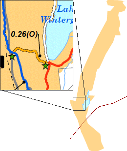 |
| The Orange Trail, as seen on the state park map. |
The trail has a steady climb from the lake up to the ridge, but the climb is never too steep.
Continue across Baldwin Drive on the Regicides Trail (Blue Blazed) and beyond to the edge of the cliff overlooking Konolds Pond. Be careful walking this trail as the edge of the overlook comes up abruptly. This area of the park was once quarried, which explains why the cliff is so sharp.
 |
Heavy snow carpets the Orange Trail during January 2011.
|
 |
From the overlook near the junction of the Orange and Regicides Trails, this is the view looking southwest into Woodbridge. The ridge drops abruptly at this location because rock was once quarried here.
|
 |
The edge of Konold's Pond is visible in this autumn view to the northwest from the overlook near the junction of the Orange and Regicides Trails.
|
Blue-White Trail
The Blue-White Trail is 0.5 miles long and starts at the junction of the White Trail, just west of the Lake Wintergreen parking area (head down the hill from the parking area and cross the White Trail).
The Blue-White Trail begins as a wide, gravel-surfaced woods road that climbs steadily to a water tank owned by the South Central Connecticut Regional Water Authority. The official trail heads south (left) around the fenced area, and then west to its terminus at the Regicides Trail.
The trail becomes a moderately steep rocky slope where it head west until it crosses Baldwin Drive. From Baldwin Drive to the Regicides Trail, the surface is dirt and the elevation change is more gradual.
The Blue-White Trail meets the Regicides Trail midway between Konold's Pond to the south and Lake Dawson to the north. I blazed this trail Gold in August 2010, which means it is an official hiking trail, and changed the color to Blue-White in August 2020.
Why the change? When I first blazed the trail in 2010, I needed to select a color because the trail had never been blazed. There are only so many basic colors that it is a challenge to find a color to use at a park like West Rock with so many trails. I chose Gold because it seemed distinct enough from other colors and was not being used at the park.
Over the years, I heard enough people refer to the trail as Yellow that I knew I had to make a change. There is already a Yellow Trail at the park, which connects Mountain Road to Baldwin Drive and the Regicides Trail. For someone hiking on Baldwin Drive or the Regicides Trail, this creates potential confusion.
The solution? Use a different color. Why Blue-White? It's simple. The water tank trail connects the Blue-Blazed Regicides Trail to the White Trail at the base of the ridge. The Blue-White Trail is the most direct connection to the Regicides Trail and Baldwin Drive from Lake Wintergreen, which is the main parking area at West Rock.
 |
| The Blue-White Trail is plowed in winter from Lake Wintergreen to the water tank, as seen in this view looking south from the tank in March 2015. |
 | ||
At the Water Tank, the Blue-White Trail turns left to loop past the fenced-in area.
|

 | ||||
Further up the slope from the water tank, almost to Baldwin Drive, the Blue-White Trail (seen with the former Gold blazes) becomes a rocky slope with little dirt to become eroded. Take care on this trail in the winter as icy rocks are difficult to climb.
|


Purple Trail
 |
| This
dotted GPS track shows the approximate path of the Purple Trail, including the extension/relocation at West Rock. The orange segment is the Purple-Orange Trail. Orange happens to be the highlight
color of Garmin BaseCamp, the software used to display this track. I was
blazing while I created this track and had my GPS in my pack, so it is not an exact track. Once I
create a better track, I will update this image. |
The Purple Trail has a half-mile extension, bringing its total distance to 1.1 miles, effective May 9, 2016. Meanwhile, the section from the start of the current relocation up the ridge to the Regicides Trail has been reblazed as Purple-Orange.
The Purple Trail starts at Main Street in Hamden, and descends slightly to where it crosses the Red Trail. The Purple Trail has a gentle rise from the Red Trail to its intersection with the White Trail. After leaving the White Trail, the Purple Trail has a steep section where it ascends the ridge before the steepness eases at a switchback section just past the junction with the Purple-White Trail.
I created this switchback section west of the junction with the Purple-White Dot Trail in Sept. 2008, replacing a steep and heavily eroded section of the Purple Trail. Users are asked to stay on this switchback; otherwise they will recreate the erosion problem that this switchback has solved. Some faint paths are appearing across the switchback, which saves people a few feet of walking, but is already causing erosion. Stay on the trail!!!
The new relocation and extension starts shortly past the switchback. The Purple Trail now turns right and continues past an overlook with a view east into Hamden. The Purple Trail relocation/extension follows the ridgeline north twisting and turning on the rugged, rocky shoulder of the ridge. The final section up the ridge is a steady climb.
At Baldwin Drive, the trail heads straight across the road and turns slightly left and descends a moderate, rocky slope along with the Regicides Trail and ends at the junction where the Regicides Trail bears left and heads south, and the North Summit Trail heads straight and descends into Woodbridge.
Where the Purple Trail meets the Regicides and North Summit Trails is a wide, paved overlook with views to the west of Lake Dawson and Glen Lake in Woodbridge.
The North Summit Trail is maintained by Woodbridge and is blazed Dark Blue-Yellow to create a cross-Woodbridge trail. I had hopes to reblaze the North Summit Trail in Purple to create a continuous trail across the ridge from Hamden to Woodbridge that would be 1.95 miles long. However, Woodbridge plans overrule mine, since it is a Woodbridge trail.
 |
| Looking up the ridge, the Purple Trail turns right at the relocated section, and goes past an overlook, while the Purple-Orange Trail bears left and heads steadily up the ridge. |
The Purple Trail changes achieve the following goals:
- Create a continuous trail from Main Street in Hamden to the Darling House property in Woodbridge
- Bring hikers to the overlook midway up the slope that was previously off-trail.
- Give the Purple Trail a better destination, i.e., the overlook of Lake Dawson and Glen Lake off Baldwin Drive, instead of simply connecting to the Regicides Trail with no real view at the junction
- Ease the climb up the ridge by extending the same amount of climbing over a half-mile trail section, instead of a quarter-mile section.
- Provide hikers with a partial view (screened by the trees) of the Metacomet Ridge as they hike north along the Purple Trail midway up the ridgeline.
 | |
| The Purple Trail starts at this gate at Main Street. This trailhead is likely to be used only by neighbors, since there is only limited street parking available and there are no other trail connections here. |
 | ||||||||||||||||||||
The Purple Trail near the White Trail provides users with a corridor of mountain laurel.
| ||||||||||||||||||||


Purple-Orange Trail
The former Purple Trail from the turn by the overlook midway up the
ridge, and extending to the Regicides Trail has become the 0.25 mile
long Purple-Orange Trail to distinguish this section from the Purple
Trail extension/relocation.
From
the junction with the Purple Trail, the Purple-Orange Trail continues
steadily up the ridge on a moderately steep rocky slope, turns right on Baldwin Drive for about 200
feet, and then turns left into the woods for a short, easy descent to
the Regicides Trail.
From
Baldwin Drive to the Regicides Trail is a trail connection that was established in September 2008 to provide a direct connection between the former Purple Trail and the Regicides Trail. Previously the former Purple Trail ended at Baldwin Drive.
 |
| The Purple-Orange Trail ends at the Purple Trail near an overlook on the Purple Trail. |
 |
| The Purple-Orange Trail descends from Baldwin Drive at this junction. |
 |
| This is the junction of the Purple-Orange Trail at the Regicides Trail as viewed from the Regicides Trail. |
Purple-White
The 0.14 mile long Purple-White Trail is a steady climb from the White Trail to the Purple Trail.
 |
| The Purple-White Trail starts at the White Trail. |
 |
| The Purple-White Trail ends at the Purple Trail. |
 |
| This is the view from the Purple-White Trail where it ends at the White Trail. |
Yellow Trail
 |
| The Yellow Trail as seen on the state park map. |
The Yellow Trail has some moderate climbs and descents in this area.
When descending the Yellow Trail to Mountain Road, turn left on Mountain Road for 0.3 miles to reach the Red Trail. There is no direct connection between the trails as there is a wetland in-between. As of June 2015, this road connection is blazed Yellow to guide people between the Yellow Trail and the Red Trail.
 |
| This ending blaze shows where the Mountain Road section of the Yellow Trail ends at the Red Trail where the Red Trail heads south. |
 | |||||
The Yellow Trail enters the woods off Mountain Road, about 1/3 mile around the corner from the Red Trail. Walk the road to connect the two trails as the terrain between the two is swampy. Blazes mark the connection along the road.
|

 |
The Yellow Trail crosses a small, seasonal stream midway up the hill. This tree fell during Hurricane Irene in Aug. 2011, and was cleared by state workers.
|
 |
The Yellow Trail junction with Baldwin Drive
when climbing the slope from Mountain Rd. |
 |
The Yellow Trail follows Baldwin Drive for 0.1 mile before turning west into the woods.
|
 |
The Yellow Trail as viewed from the west side of Baldwin Drive.
|
 |
The Yellow Trail as it approaches the junction with the Regicides Trail.
|
 |
The Yellow Trail as viewed from the Regicides Trail.
|
Nice work on the purple trail extension!
ReplyDeleteI have now hiked all of these summit trails. Nice job on the trails, and on this web site. Great descriptions, maps, and photos!
ReplyDelete